Koudougou geodata
Koudougou (Centre-Ouest) is a seat of a first-order administrative division; located in Burkina Faso in Africa/Ouagadougou (GMT+0) time zone. With population of 87,347 people, there are 2 cities with bigger population in this country. Compared to other cities in Burkina Faso, 60.8% of cities are located further ↑North; 77.2% of cities are located further →East and 51.9% of cities have higher elevation than Koudougou. Note1


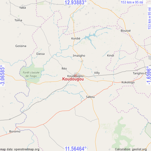
Koudougou GPS coordinates[2]
12° 15' 9.468" North, 2° 21' 45.792" West
| Map corner | latitude | longitude |
|---|---|---|
| Upper-left | 12.93883°, | -3.06585° |
| Center: | 12.25263°, | -2.36272° |
| Lower-right: | 11.56464°, | -1.6596° |
| Map W x H: | 152.8×152.8 km | = 94.9×94.9mi |
| max Lat: | 14.96549° ⇑60.8% North |
| Koudougou: | 12.25263° |
| min Lat: | ⇓39.2% South 9.88333° |
| min Long | Koudougou | max Long |
| -5.16667° | -2.36272° | 1.78838° |
| W 22.8%⇐ | ⇒77.2% E |
Elevation
Elevation of Koudougou is 303 m = 994 ft, and this is 0 m = 0 ft above average elevation for this country.
| Max E: |
423 m = 1388 ft | 51.9% |
| Koudougou | 303 m 994 ft | |
| Avg. | 303 m = 994 ft | |
Min E: |
222 m = 728 ft | 48.1% |
See also: Koudougou elevation on elevation.city.
Geographical zone
Koudougou is located in North Torrid zone (between Equator and Tropic of Cancer). Distance of this Northern Tropic circle is 1243.6 km =772.7 mi to North.| Distance of | km | miles | from Koudougou |
|---|---|---|---|
| North Pole | 8644.7 | 5371.6 | to North |
| Arctic Circle | 6038.8 | 3752.3 | to North |
| Tropic Cancer | 1243.6 | 772.7 | to North |
| Equator | 1362.4 | 846.6 | to South |


Nearby cities:
15 places around Koudougou: (largest is in red/bold)
• Bingo
57.6 km =35.8 mi,  84°
84°
• Boussé
68.1 km =42.3 mi,  48°
48°
• Goulouré
46.6 km =29 mi,  92°
92°
• Gousi
64.9 km =40.3 mi,  313°
313°
• Kayao
62.6 km =38.9 mi,  115°
115°
• Kokologo
53.2 km =33.1 mi,  97°
97°
• Komki-Ipala
62.6 km =38.9 mi, 97°
• Laye
70.8 km =44 mi,  64°
64°
• Niou
74 km =46 mi,  39°
39°
• Pitmoaga
52.3 km =32.5 mi, 90°
• Réo
13.9 km =8.6 mi,  302°
302°
• Siglé
61.6 km =38.3 mi, 56°
• Sièn
76 km =47.2 mi, 310°
• Sourgoubila
63.1 km =39.2 mi,  73°
73°
• Tanghin-Dassouri
70.2 km =43.6 mi, 88°
Sources, notices
• [Note1] Compared only with cities in Burkina Faso existing in our database
• [Src1] Map data: © OpenStreetMap contributors (CC-BY-SA)
• [Src2] Other city data from geonames.org with taken over terms of usage.
• [Src3] Geographical zone / Annual Mean Temperature by Robert A. Rohde @ Wikipedia
