Gousi geodata
Gousi (Boucle du Mouhoun) is a populated place; located in Burkina Faso in Africa/Ouagadougou (GMT+0) time zone. With population of 516 people, there are 48 cities with bigger population in this country. Compared to other cities in Burkina Faso, 60.8% of cities are located further ↓South; 81% of cities are located further →East and 87.3% of cities have higher elevation than Gousi. Note1


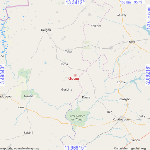
Gousi GPS coordinates[2]
12° 39' 21.96" North, 2° 47' 43.08" West
| Map corner | latitude | longitude |
|---|---|---|
| Upper-left | 13.3412°, | -3.49843° |
| Center: | 12.6561°, | -2.7953° |
| Lower-right: | 11.96915°, | -2.09218° |
| Map W x H: | 152.6×152.6 km | = 94.8×94.8mi |
| max Lat: | 14.96549° ⇑39.2% North |
| Gousi: | 12.6561° |
| min Lat: | ⇓60.8% South 9.88333° |
| min Long | Gousi | max Long |
| -5.16667° | -2.7953° | 1.78838° |
| W 19%⇐ | ⇒81% E |
Elevation
Elevation of Gousi is 271 m = 889 ft, and this is 32 m = 105 ft below average elevation for this country.
| Max E: |
423 m = 1388 ft | 87.3% |
| Avg. | 303 m = 994 ft | |
| Gousi | 271 m = 889 ft | |
Min E: |
222 m = 728 ft | 12.7% |
See also: Burkina Faso elevation on elevation.city.
Geographical zone
Gousi is located in North Torrid zone (between Equator and Tropic of Cancer). Distance of this Northern Tropic circle is 1198.7 km =744.8 mi to North.| Distance of | km | miles | from Gousi |
|---|---|---|---|
| North Pole | 8599.8 | 5343.7 | to North |
| Arctic Circle | 5993.9 | 3724.4 | to North |
| Tropic Cancer | 1198.7 | 744.8 | to North |
| Equator | 1407.2 | 874.4 | to South |


Nearby cities:
15 places around Gousi: (largest is in red/bold)
• Boromo
102.3 km =63.6 mi,  188°
188°
• Boussé
97.7 km =60.7 mi,  89°
89°
• Dédougou
75.3 km =46.8 mi,  253°
253°
• Goulouré
104.6 km =65 mi,  116°
116°
• Gourcy
77.5 km =48.2 mi,  37°
37°
• Koudougou
64.9 km =40.3 mi,  133°
133°
• Niou
94.3 km =58.6 mi,  82°
82°
• Pitmoaga
109.2 km =67.9 mi,  114°
114°
• Réo
51.4 km =31.9 mi,  136°
136°
• Siglé
99.1 km =61.6 mi,  96°
96°
• Sièn
11.9 km =7.4 mi,  289°
289°
• Sourgoubila
110.6 km =68.7 mi, 104°
• Toma
16 km =9.9 mi,  315°
315°
• Tougan
55 km =34.2 mi,  327°
327°
• Yako
67 km =41.6 mi,  59°
59°
Sources, notices
• [Note1] Compared only with cities in Burkina Faso existing in our database
• [Src1] Map data: © OpenStreetMap contributors (CC-BY-SA)
• [Src2] Other city data from geonames.org with taken over terms of usage.
• [Src3] Geographical zone / Annual Mean Temperature by Robert A. Rohde @ Wikipedia
