Borovets geodata
Borovets (Kyustendil) is a populated place; located in Bulgaria in Europe/Sofia (GMT+3) time zone. With population of 800 people, there are 280 cities with bigger population in this country. Compared to other cities in Bulgaria, 80% of cities are located further ↑North; 92% of cities are located further →East and 69% of cities have lower elevation than Borovets. Note1


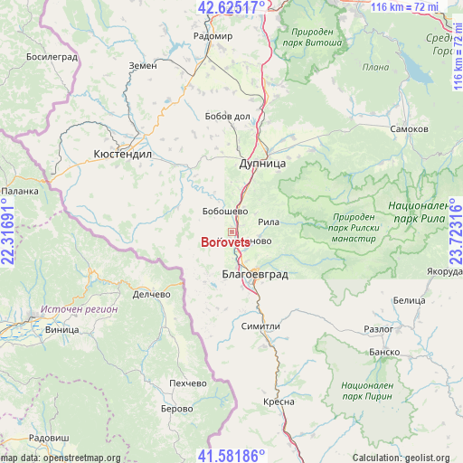
Borovets GPS coordinates[2]
42° 6' 20.376" North, 23° 1' 12.108" East
| Map corner | latitude | longitude |
|---|---|---|
| Upper-left | 42.62517°, | 22.31691° |
| Center: | 42.10566°, | 23.02003° |
| Lower-right: | 41.58186°, | 23.72316° |
| Map W x H: | 116×116 km | = 72.1×72.1mi |
| max Lat: | 44.16214° ⇑80% North |
| Borovets: | 42.10566° |
| min Lat: | ⇓20% South 41.32715° |
| min Long | Borovets | max Long |
| 22.52139° | 23.02003° | 28.53429° |
| W 8%⇐ | ⇒92% E |
Elevation
Elevation of Borovets is 389 m = 1276 ft, and this is 72.4 m = 238 ft above average elevation for this country.
| Max E: |
1221 m = 4006 ft | 31% |
| Borovets | 389 m 1276 ft | |
| Avg. | 316.6 m = 1039 ft | |
Min E: |
1 m = 3 ft | 69% |
See also: Bulgaria elevation on elevation.city.
Geographical zone
Borovets is located in North temperate zone (between Tropic of Cancer and the Arctic Circle). Distance of this Northern Tropic circle is 2075.8 km =1289.8 mi to South.| Distance of | km | miles | from Borovets |
|---|---|---|---|
| North Pole | 5325.4 | 3309 | to North |
| Arctic Circle | 2719.5 | 1689.8 | to North |
| Tropic Cancer | 2075.8 | 1289.8 | to South |
| Equator | 4681.7 | 2909.1 | to South |


Nearby cities:
15 places around Borovets: (largest is in red/bold)
• Blagoevgrad
11.9 km =7.4 mi,  146°
146°
• Boboshevo
5.5 km =3.4 mi,  343°
343°
• Bobov Dol
28.6 km =17.8 mi,  357°
357°
• Dupnitsa
19.6 km =12.2 mi,  23°
23°
• Kocherinovo
3.9 km =2.4 mi,  127°
127°
• Kresna
42.8 km =26.6 mi,  165°
165°
• Kyustendil
33.6 km =20.9 mi,  306°
306°
• Nevestino
21.7 km =13.5 mi,  320°
320°
• Porominovo
6.3 km =3.9 mi,  120°
120°
• Razlog
44.3 km =27.5 mi, 123°
• Rila
9.8 km =6.1 mi,  71°
71°
• Sapareva Banya
28.3 km =17.6 mi,  45°
45°
• Simitli
26 km =16.2 mi,  162°
162°
• Stara Kresna
36.6 km =22.7 mi, 158°
• Zemen
47.1 km =29.3 mi,  331°
331°
Sources, notices
• [Note1] Compared only with cities in Bulgaria existing in our database
• [Src1] Map data: © OpenStreetMap contributors (CC-BY-SA)
• [Src2] Other city data from geonames.org with taken over terms of usage.
• [Src3] Geographical zone / Annual Mean Temperature by Robert A. Rohde @ Wikipedia
