Boboshevo geodata
Boboshevo (Kyustendil) is a populated place; located in Bulgaria in Europe/Sofia (GMT+3) time zone. With population of 1,784 people, there are 238 cities with bigger population in this country. Compared to other cities in Bulgaria, 77.7% of cities are located further ↑North; 92.7% of cities are located further →East and 68.7% of cities have lower elevation than Boboshevo. Note1


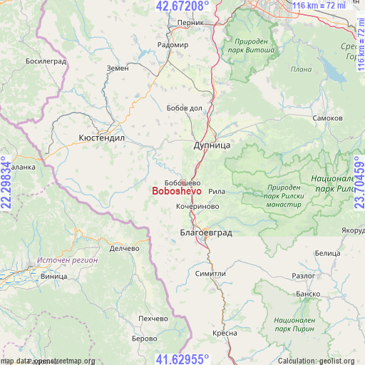
Boboshevo GPS coordinates[2]
42° 9' 10.656" North, 23° 0' 5.256" East
| Map corner | latitude | longitude |
|---|---|---|
| Upper-left | 42.67208°, | 22.29834° |
| Center: | 42.15296°, | 23.00146° |
| Lower-right: | 41.62955°, | 23.70459° |
| Map W x H: | 115.9×115.9 km | = 72×72mi |
| max Lat: | 44.16214° ⇑77.7% North |
| Boboshevo: | 42.15296° |
| min Lat: | ⇓22.3% South 41.32715° |
| min Long | Boboshevo | max Long |
| 22.52139° | 23.00146° | 28.53429° |
| W 7.3%⇐ | ⇒92.7% E |
Elevation
Elevation of Boboshevo is 376 m = 1234 ft, and this is 59.4 m = 195 ft above average elevation for this country.
| Max E: |
1221 m = 4006 ft | 31.3% |
| Boboshevo | 376 m 1234 ft | |
| Avg. | 316.6 m = 1039 ft | |
Min E: |
1 m = 3 ft | 68.7% |
See also: Bulgaria elevation on elevation.city.
Geographical zone
Boboshevo is located in North temperate zone (between Tropic of Cancer and the Arctic Circle). Distance of this Northern Tropic circle is 2081.1 km =1293.1 mi to South.| Distance of | km | miles | from Boboshevo |
|---|---|---|---|
| North Pole | 5320.1 | 3305.8 | to North |
| Arctic Circle | 2714.2 | 1686.5 | to North |
| Tropic Cancer | 2081.1 | 1293.1 | to South |
| Equator | 4687 | 2912.4 | to South |


Nearby cities:
15 places around Boboshevo: (largest is in red/bold)
• Blagoevgrad
17.2 km =10.7 mi,  151°
151°
• Bobov Dol
23.3 km =14.5 mi,  0°
0°
• Borovets
5.5 km =3.4 mi,  163°
163°
• Dupnitsa
15.8 km =9.8 mi,  36°
36°
• Kocherinovo
8.9 km =5.5 mi, 148°
• Kresna
48.2 km =30 mi,  165°
165°
• Kyustendil
29.4 km =18.3 mi,  299°
299°
• Nevestino
16.8 km =10.4 mi,  312°
312°
• Porominovo
11 km =6.8 mi,  140°
140°
• Radomir
43.8 km =27.2 mi,  356°
356°
• Rila
11.1 km =6.9 mi,  101°
101°
• Sapareva Banya
26.2 km =16.3 mi,  56°
56°
• Simitli
31.5 km =19.6 mi, 162°
• Stara Kresna
42 km =26.1 mi, 159°
• Zemen
41.8 km =26 mi,  330°
330°
Sources, notices
• [Note1] Compared only with cities in Bulgaria existing in our database
• [Src1] Map data: © OpenStreetMap contributors (CC-BY-SA)
• [Src2] Other city data from geonames.org with taken over terms of usage.
• [Src3] Geographical zone / Annual Mean Temperature by Robert A. Rohde @ Wikipedia
