Sungurlare geodata
Sungurlare (Burgas) is a populated place; located in Bulgaria in Europe/Sofia (GMT+3) time zone. With population of 3,834 people, there are 161 cities with bigger population in this country. Compared to other cities in Bulgaria, 52% of cities are located further ↑North; 78.3% of cities are located further ←West and 54.3% of cities have higher elevation than Sungurlare. Note1


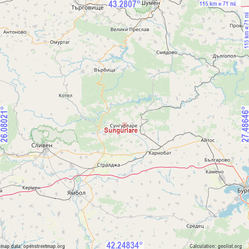
Sungurlare GPS coordinates[2]
42° 46' 0.012" North, 26° 46' 59.988" East
| Map corner | latitude | longitude |
|---|---|---|
| Upper-left | 43.2807°, | 26.08021° |
| Center: | 42.76667°, | 26.78333° |
| Lower-right: | 42.24834°, | 27.48646° |
| Map W x H: | 114.8×114.8 km | = 71.3×71.3mi |
| max Lat: | 44.16214° ⇑52% North |
| Sungurlare: | 42.76667° |
| min Lat: | ⇓48% South 41.32715° |
| min Long | Sungurlare | max Long |
| 22.52139° | 26.78333° | 28.53429° |
| W 78.3%⇐ | ⇒21.7% E |
Elevation
Elevation of Sungurlare is 206 m = 676 ft, and this is 110.6 m = 363 ft below average elevation for this country.
| Max E: |
1221 m = 4006 ft | 54.3% |
| Avg. | 316.6 m = 1039 ft | |
| Sungurlare | 206 m = 676 ft | |
Min E: |
1 m = 3 ft | 45.7% |
See also: Bulgaria elevation on elevation.city.
Geographical zone
Sungurlare is located in North temperate zone (between Tropic of Cancer and the Arctic Circle). Distance of this Northern Tropic circle is 2149.3 km =1335.5 mi to South.| Distance of | km | miles | from Sungurlare |
|---|---|---|---|
| North Pole | 5251.9 | 3263.4 | to North |
| Arctic Circle | 2646 | 1644.1 | to North |
| Tropic Cancer | 2149.3 | 1335.5 | to South |
| Equator | 4755.2 | 2954.7 | to South |


Nearby cities:
15 places around Sungurlare: (largest is in red/bold)
• Aytos
38.8 km =24.1 mi,  101°
101°
• Dalgopol
55.9 km =34.7 mi,  55°
55°
• Kameno
47.4 km =29.5 mi,  117°
117°
• Karnobat
20.9 km =13 mi,  128°
128°
• Kermen
52.7 km =32.7 mi,  235°
235°
• Kiten
55.9 km =34.7 mi,  50°
50°
• Kotel
30.1 km =18.7 mi,  295°
295°
• Omurtag
47.6 km =29.6 mi,  321°
321°
• Ruen
41 km =25.5 mi,  84°
84°
• Sliven
38.2 km =23.7 mi,  256°
256°
• Smyadovo
38.4 km =23.9 mi,  29°
29°
• Straldzha
20.3 km =12.6 mi,  203°
203°
• Varbitsa
28.7 km =17.8 mi,  334°
334°
• Veliki Preslav
44.6 km =27.7 mi,  3°
3°
• Yambol
39.1 km =24.3 mi,  216°
216°
Sources, notices
• [Note1] Compared only with cities in Bulgaria existing in our database
• [Src1] Map data: © OpenStreetMap contributors (CC-BY-SA)
• [Src2] Other city data from geonames.org with taken over terms of usage.
• [Src3] Geographical zone / Annual Mean Temperature by Robert A. Rohde @ Wikipedia
