Primorsko geodata
Primorsko (Burgas) is a seat of a second-order administrative division; located in Bulgaria in Europe/Sofia (GMT+3) time zone. With population of 2,798 people, there are 206 cities with bigger population in this country. Compared to other cities in Bulgaria, 73.7% of cities are located further ↑North; 93.7% of cities are located further ←West and 97.3% of cities have higher elevation than Primorsko. Note1


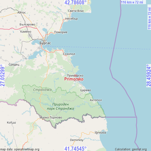
Primorsko GPS coordinates[2]
42° 16' 4.476" North, 27° 45' 21.996" East
| Map corner | latitude | longitude |
|---|---|---|
| Upper-left | 42.78608°, | 27.05299° |
| Center: | 42.26791°, | 27.75611° |
| Lower-right: | 41.74545°, | 28.45924° |
| Map W x H: | 115.7×115.7 km | = 71.9×71.9mi |
| max Lat: | 44.16214° ⇑73.7% North |
| Primorsko: | 42.26791° |
| min Lat: | ⇓26.3% South 41.32715° |
| min Long | Primorsko | max Long |
| 22.52139° | 27.75611° | 28.53429° |
| W 93.7%⇐ | ⇒6.3% E |
Elevation
Elevation of Primorsko is 21 m = 69 ft, and this is 295.6 m = 970 ft below average elevation for this country.
| Max E: |
1221 m = 4006 ft | 97.3% |
| Avg. | 316.6 m = 1039 ft | |
| Primorsko | 21 m = 69 ft | |
Min E: |
1 m = 3 ft | 2.7% |
See also: Bulgaria elevation on elevation.city.
Geographical zone
Primorsko is located in North temperate zone (between Tropic of Cancer and the Arctic Circle). Distance of this Northern Tropic circle is 2093.8 km =1301 mi to South.| Distance of | km | miles | from Primorsko |
|---|---|---|---|
| North Pole | 5307.3 | 3297.8 | to North |
| Arctic Circle | 2701.4 | 1678.6 | to North |
| Tropic Cancer | 2093.8 | 1301 | to South |
| Equator | 4699.8 | 2920.3 | to South |


Nearby cities:
15 places around Primorsko: (largest is in red/bold)
• Aheloy
43.4 km =27 mi,  348°
348°
• Ahtopol
24.2 km =15 mi,  141°
141°
• Burgas
35.5 km =22.1 mi,  318°
318°
• Chernomorets
21.8 km =13.5 mi,  333°
333°
• Kameno
50.4 km =31.3 mi,  311°
311°
• Kiten
4.1 km =2.5 mi,  157°
157°
• Malko Tarnovo
37.3 km =23.2 mi,  210°
210°
• Nesebar
43.5 km =27 mi,  357°
357°
• Pomorie
34.4 km =21.4 mi,  342°
342°
• Ravda
42.1 km =26.2 mi, 351°
• Sarafovo
37.8 km =23.5 mi, 329°
• Sozopol
17.4 km =10.8 mi, 343°
• Sredets
48.3 km =30 mi,  280°
280°
• Sveti Vlas
49.6 km =30.8 mi,  0°
0°
• Tsarevo
13.2 km =8.2 mi,  146°
146°
Sources, notices
• [Note1] Compared only with cities in Bulgaria existing in our database
• [Src1] Map data: © OpenStreetMap contributors (CC-BY-SA)
• [Src2] Other city data from geonames.org with taken over terms of usage.
• [Src3] Geographical zone / Annual Mean Temperature by Robert A. Rohde @ Wikipedia
