Tsarevo geodata
Tsarevo (Burgas) is a populated place; located in Bulgaria in Europe/Sofia (GMT+3) time zone. With population of 6,085 people, there are 118 cities with bigger population in this country. Compared to other cities in Bulgaria, 77% of cities are located further ↑North; 95.3% of cities are located further ←West and 90.7% of cities have higher elevation than Tsarevo. Note1


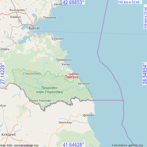
Tsarevo GPS coordinates[2]
42° 10' 10.38" North, 27° 50' 43.476" East
| Map corner | latitude | longitude |
|---|---|---|
| Upper-left | 42.68853°, | 27.14229° |
| Center: | 42.16955°, | 27.84541° |
| Lower-right: | 41.64628°, | 28.54854° |
| Map W x H: | 115.9×115.9 km | = 72×72mi |
| max Lat: | 44.16214° ⇑77% North |
| Tsarevo: | 42.16955° |
| min Lat: | ⇓23% South 41.32715° |
| min Long | Tsarevo | max Long |
| 22.52139° | 27.84541° | 28.53429° |
| W 95.3%⇐ | ⇒4.7% E |
Elevation
Elevation of Tsarevo is 36 m = 118 ft, and this is 280.6 m = 921 ft below average elevation for this country.
| Max E: |
1221 m = 4006 ft | 90.7% |
| Avg. | 316.6 m = 1039 ft | |
| Tsarevo | 36 m = 118 ft | |
Min E: |
1 m = 3 ft | 9.3% |
See also: Bulgaria elevation on elevation.city.
Geographical zone
Tsarevo is located in North temperate zone (between Tropic of Cancer and the Arctic Circle). Distance of this Northern Tropic circle is 2082.9 km =1294.3 mi to South.| Distance of | km | miles | from Tsarevo |
|---|---|---|---|
| North Pole | 5318.2 | 3304.6 | to North |
| Arctic Circle | 2712.4 | 1685.4 | to North |
| Tropic Cancer | 2082.9 | 1294.3 | to South |
| Equator | 4688.8 | 2913.5 | to South |


Nearby cities:
15 places around Tsarevo: (largest is in red/bold)
• Aheloy
55.8 km =34.7 mi,  343°
343°
• Ahtopol
11.1 km =6.9 mi,  135°
135°
• Burgas
48.6 km =30.2 mi,  320°
320°
• Chernomorets
34.9 km =21.7 mi,  330°
330°
• Kameno
63.3 km =39.3 mi,  314°
314°
• Kiten
9.2 km =5.7 mi, 321°
• Malko Tarnovo
33.9 km =21.1 mi,  231°
231°
• Nesebar
55.2 km =34.3 mi,  350°
350°
• Pomorie
47.2 km =29.3 mi, 337°
• Primorsko
13.2 km =8.2 mi, 326°
• Ravda
54.3 km =33.7 mi, 345°
• Sarafovo
51 km =31.7 mi, 328°
• Sozopol
30.2 km =18.8 mi, 335°
• Sredets
58.3 km =36.2 mi,  289°
289°
• Sveti Vlas
60.9 km =37.8 mi, 353°
Sources, notices
• [Note1] Compared only with cities in Bulgaria existing in our database
• [Src1] Map data: © OpenStreetMap contributors (CC-BY-SA)
• [Src2] Other city data from geonames.org with taken over terms of usage.
• [Src3] Geographical zone / Annual Mean Temperature by Robert A. Rohde @ Wikipedia
