Sredets geodata
Sredets (Burgas) is a populated place; located in Bulgaria in Europe/Sofia (GMT+3) time zone. With population of 9,573 people, there are 82 cities with bigger population in this country. Compared to other cities in Bulgaria, 71% of cities are located further ↑North; 83.3% of cities are located further ←West and 96% of cities have higher elevation than Sredets. Note1


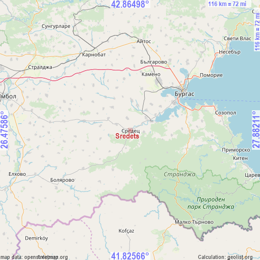
Sredets GPS coordinates[2]
42° 20' 50.892" North, 27° 10' 44.328" East
| Map corner | latitude | longitude |
|---|---|---|
| Upper-left | 42.86498°, | 26.47586° |
| Center: | 42.34747°, | 27.17898° |
| Lower-right: | 41.82566°, | 27.88211° |
| Map W x H: | 115.6×115.6 km | = 71.8×71.8mi |
| max Lat: | 44.16214° ⇑71% North |
| Sredets: | 42.34747° |
| min Lat: | ⇓29% South 41.32715° |
| min Long | Sredets | max Long |
| 22.52139° | 27.17898° | 28.53429° |
| W 83.3%⇐ | ⇒16.7% E |
Elevation
Elevation of Sredets is 25 m = 82 ft, and this is 291.6 m = 957 ft below average elevation for this country.
| Max E: |
1221 m = 4006 ft | 96% |
| Avg. | 316.6 m = 1039 ft | |
| Sredets | 25 m = 82 ft | |
Min E: |
1 m = 3 ft | 4% |
See also: Bulgaria elevation on elevation.city.
Geographical zone
Sredets is located in North temperate zone (between Tropic of Cancer and the Arctic Circle). Distance of this Northern Tropic circle is 2102.7 km =1306.6 mi to South.| Distance of | km | miles | from Sredets |
|---|---|---|---|
| North Pole | 5298.5 | 3292.3 | to North |
| Arctic Circle | 2692.6 | 1673.1 | to North |
| Tropic Cancer | 2102.7 | 1306.6 | to South |
| Equator | 4708.6 | 2925.8 | to South |


Nearby cities:
15 places around Sredets: (largest is in red/bold)
• Aytos
39.6 km =24.6 mi,  8°
8°
• Bata
50.6 km =31.4 mi,  30°
30°
• Bolyarovo
37.4 km =23.2 mi,  233°
233°
• Burgas
29.5 km =18.3 mi,  53°
53°
• Chernomorets
39.3 km =24.4 mi,  74°
74°
• Kameno
26.7 km =16.6 mi,  21°
21°
• Karnobat
37.3 km =23.2 mi,  334°
334°
• Kiten
50.6 km =31.4 mi,  104°
104°
• Malko Tarnovo
49.9 km =31 mi,  145°
145°
• Pomorie
44.1 km =27.4 mi,  57°
57°
• Primorsko
48.3 km =30 mi, 100°
• Ruen
51 km =31.7 mi, 9°
• Sarafovo
36.8 km =22.9 mi, 49°
• Sozopol
43.1 km =26.8 mi,  79°
79°
• Straldzha
49.4 km =30.7 mi,  304°
304°
Sources, notices
• [Note1] Compared only with cities in Bulgaria existing in our database
• [Src1] Map data: © OpenStreetMap contributors (CC-BY-SA)
• [Src2] Other city data from geonames.org with taken over terms of usage.
• [Src3] Geographical zone / Annual Mean Temperature by Robert A. Rohde @ Wikipedia
