Sliven geodata
Sliven is a seat of a first-order administrative division; located in Bulgaria in Europe/Sofia (GMT+3) time zone. With population of 96,368 people, there are 7 cities with bigger population in this country. Compared to other cities in Bulgaria, 57% of cities are located further ↑North; 72% of cities are located further ←West and 57.3% of cities have lower elevation than Sliven. Note1


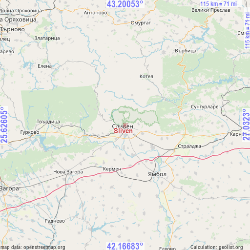
Sliven GPS coordinates[2]
42° 41' 8.988" North, 26° 19' 45.012" East
| Map corner | latitude | longitude |
|---|---|---|
| Upper-left | 43.20053°, | 25.62605° |
| Center: | 42.68583°, | 26.32917° |
| Lower-right: | 42.16683°, | 27.0323° |
| Map W x H: | 114.9×114.9 km | = 71.4×71.4mi |
| max Lat: | 44.16214° ⇑57% North |
| Sliven: | 42.68583° |
| min Lat: | ⇓43% South 41.32715° |
| min Long | Sliven | max Long |
| 22.52139° | 26.32917° | 28.53429° |
| W 72%⇐ | ⇒28% E |
Elevation
Elevation of Sliven is 271 m = 889 ft, and this is 45.6 m = 150 ft below average elevation for this country.
| Max E: |
1221 m = 4006 ft | 42.7% |
| Avg. | 316.6 m = 1039 ft | |
| Sliven | 271 m = 889 ft | |
Min E: |
1 m = 3 ft | 57.3% |
See also: Sliven elevation on elevation.city.
Geographical zone
Sliven is located in North temperate zone (between Tropic of Cancer and the Arctic Circle). Distance of this Northern Tropic circle is 2140.3 km =1329.9 mi to South.| Distance of | km | miles | from Sliven |
|---|---|---|---|
| North Pole | 5260.8 | 3268.9 | to North |
| Arctic Circle | 2655 | 1649.7 | to North |
| Tropic Cancer | 2140.3 | 1329.9 | to South |
| Equator | 4746.2 | 2949.2 | to South |


Nearby cities:
15 places around Sliven: (largest is in red/bold)
• Antonovo
53.3 km =33.1 mi,  345°
345°
• Elena
45.6 km =28.3 mi,  307°
307°
• Gurkovo
43.3 km =26.9 mi,  267°
267°
• Karnobat
53.6 km =33.3 mi,  94°
94°
• Kermen
21.7 km =13.5 mi,  197°
197°
• Kotel
24.1 km =15 mi,  24°
24°
• Nikolaevo
43.7 km =27.2 mi,  262°
262°
• Nova Zagora
34.1 km =21.2 mi,  228°
228°
• Omurtag
46.6 km =29 mi,  8°
8°
• Straldzha
30.5 km =19 mi,  108°
108°
• Sungurlare
38.2 km =23.7 mi,  76°
76°
• Tvarditsa
35.1 km =21.8 mi, 272°
• Varbitsa
42.8 km =26.6 mi,  35°
35°
• Yambol
26.5 km =16.5 mi,  148°
148°
• Zlataritsa
53.5 km =33.2 mi,  319°
319°
Sources, notices
• [Note1] Compared only with cities in Bulgaria existing in our database
• [Src1] Map data: © OpenStreetMap contributors (CC-BY-SA)
• [Src2] Other city data from geonames.org with taken over terms of usage.
• [Src3] Geographical zone / Annual Mean Temperature by Robert A. Rohde @ Wikipedia
