Savalou geodata
Savalou (Collines) is a seat of a first-order administrative division; located in Benin in Africa/Porto-Novo (GMT+1) time zone. With population of 30,187 people, there are 17 cities with bigger population in this country. Compared to other cities in Benin, 65.2% of cities are located further ↓South; 78.3% of cities are located further →East and 65.2% of cities have lower elevation than Savalou. Note1


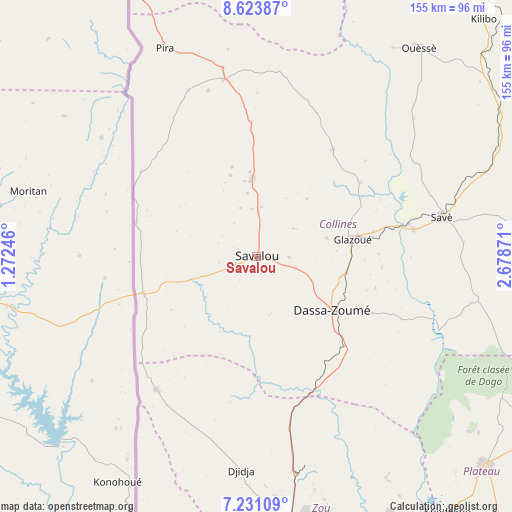
Savalou GPS coordinates[2]
7° 55' 41.052" North, 1° 58' 32.088" East
| Map corner | latitude | longitude |
|---|---|---|
| Upper-left | 8.62387°, | 1.27246° |
| Center: | 7.92807°, | 1.97558° |
| Lower-right: | 7.23109°, | 2.67871° |
| Map W x H: | 154.9×154.9 km | = 96.3×96.3mi |
| max Lat: | 11.86819° ⇑34.8% North |
| Savalou: | 7.92807° |
| min Lat: | ⇓65.2% South 6.28036° |
| min Long | Savalou | max Long |
| 1.26651° | 1.97558° | 3.38327° |
| W 21.7%⇐ | ⇒78.3% E |
Elevation
Elevation of Savalou is 181 m = 594 ft, and this is 18.2 m = 60 ft above average elevation for this country.
| Max E: |
472 m = 1549 ft | 34.8% |
| Savalou | 181 m 594 ft | |
| Avg. | 162.8 m = 534 ft | |
Min E: |
1 m = 3 ft | 65.2% |
See also: Benin elevation on elevation.city.
Geographical zone
Savalou is located in North Torrid zone (between Equator and Tropic of Cancer). Distance of Equator is 881.5 km =547.7 mi to South.| Distance of | km | miles | from Savalou |
|---|---|---|---|
| North Pole | 9125.5 | 5670.3 | to North |
| Arctic Circle | 6519.7 | 4051.2 | to North |
| Tropic Cancer | 1724.4 | 1071.5 | to North |
| Equator | 881.5 | 547.7 | to South |


Nearby cities:
15 places around Savalou: (largest is in red/bold)
• Abomey
82.9 km =51.5 mi,  178°
178°
• Aplahoué
115.2 km =71.6 mi,  196°
196°
• Bassila
124.8 km =77.5 mi,  344°
344°
• Bohicon
84 km =52.2 mi,  173°
173°
• Cové
88.3 km =54.9 mi,  152°
152°
• Dassa-Zoumé
30.3 km =18.8 mi,  130°
130°
• Dogbo
127.4 km =79.2 mi,  189°
189°
• Hinvi
130.8 km =81.3 mi, 170°
• Houinvigue
128.5 km =79.8 mi, 154°
• Kétou
93.1 km =57.8 mi, 132°
• Ouinhi
109.3 km =67.9 mi, 149°
• Pobé
129.9 km =80.7 mi,  144°
144°
• Savé
57.5 km =35.7 mi,  78°
78°
• Tchaourou
126.6 km =78.7 mi,  32°
32°
• Zagnanado
90.6 km =56.3 mi, 150°
Sources, notices
• [Note1] Compared only with cities in Benin existing in our database
• [Src1] Map data: © OpenStreetMap contributors (CC-BY-SA)
• [Src2] Other city data from geonames.org with taken over terms of usage.
• [Src3] Geographical zone / Annual Mean Temperature by Robert A. Rohde @ Wikipedia
