Bassila geodata
Bassila (Donga) is a populated place; located in Benin in Africa/Porto-Novo (GMT+1) time zone. With population of 23,616 people, there are 21 cities with bigger population in this country. Compared to other cities in Benin, 71.7% of cities are located further ↓South; 95.7% of cities are located further →East and 89.1% of cities have lower elevation than Bassila. Note1


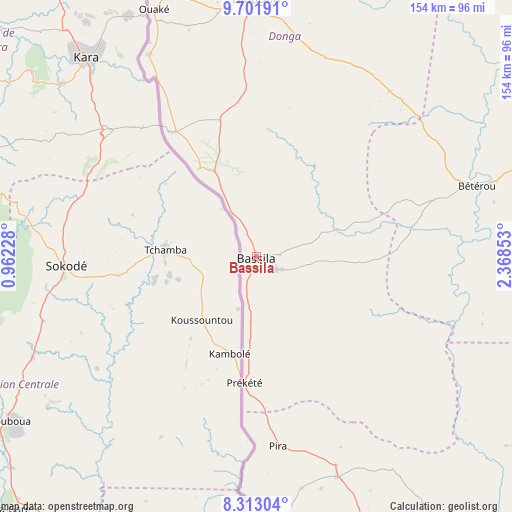
Bassila GPS coordinates[2]
9° 0' 29.304" North, 1° 39' 55.44" East
| Map corner | latitude | longitude |
|---|---|---|
| Upper-left | 9.70191°, | 0.96228° |
| Center: | 9.00814°, | 1.6654° |
| Lower-right: | 8.31304°, | 2.36853° |
| Map W x H: | 154.4×154.4 km | = 95.9×95.9mi |
| max Lat: | 11.86819° ⇑28.3% North |
| Bassila: | 9.00814° |
| min Lat: | ⇓71.7% South 6.28036° |
| min Long | Bassila | max Long |
| 1.26651° | 1.6654° | 3.38327° |
| W 4.3%⇐ | ⇒95.7% E |
Elevation
Elevation of Bassila is 388 m = 1273 ft, and this is 225.2 m = 739 ft above average elevation for this country.
| Max E: |
472 m = 1549 ft | 10.9% |
| Bassila | 388 m 1273 ft | |
| Avg. | 162.8 m = 534 ft | |
Min E: |
1 m = 3 ft | 89.1% |
See also: Benin elevation on elevation.city.
Geographical zone
Bassila is located in North Torrid zone (between Equator and Tropic of Cancer). Distance of Equator is 1001.6 km =622.4 mi to South.| Distance of | km | miles | from Bassila |
|---|---|---|---|
| North Pole | 9005.5 | 5595.8 | to North |
| Arctic Circle | 6399.6 | 3976.5 | to North |
| Tropic Cancer | 1604.3 | 996.9 | to North |
| Equator | 1001.6 | 622.4 | to South |


Nearby cities:
15 places around Bassila: (largest is in red/bold)
• Abomey
206.1 km =128.1 mi,  169°
169°
• Bembèrèkè
174.3 km =108.3 mi,  38°
38°
• Bohicon
208.2 km =129.4 mi, 167°
• Bétérou
68.5 km =42.6 mi,  71°
71°
• Dassa-Zoumé
151 km =93.8 mi,  157°
157°
• Djougou
77.9 km =48.4 mi,  0°
0°
• Guilmaro
173.3 km =107.7 mi, 2°
• Kétou
209.8 km =130.4 mi,  150°
150°
• Natitingou
147.5 km =91.7 mi,  347°
347°
• Nikki
198.6 km =123.4 mi,  58°
58°
• Parakou
112.1 km =69.7 mi, 70°
• Savalou
124.8 km =77.5 mi, 164°
• Savé
141 km =87.6 mi,  140°
140°
• Tanguiéta
184.6 km =114.7 mi, 346°
• Tchaourou
103.3 km =64.2 mi,  97°
97°
Sources, notices
• [Note1] Compared only with cities in Benin existing in our database
• [Src1] Map data: © OpenStreetMap contributors (CC-BY-SA)
• [Src2] Other city data from geonames.org with taken over terms of usage.
• [Src3] Geographical zone / Annual Mean Temperature by Robert A. Rohde @ Wikipedia
