Tchaourou geodata
Tchaourou (Borgou) is a populated place; located in Benin in Africa/Porto-Novo (GMT+1) time zone. With population of 20,971 people, there are 25 cities with bigger population in this country. Compared to other cities in Benin, 69.6% of cities are located further ↓South; 73.9% of cities are located further ←West and 84.8% of cities have lower elevation than Tchaourou. Note1


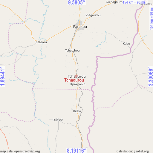
Tchaourou GPS coordinates[2]
8° 53' 11.364" North, 2° 35' 51.108" East
| Map corner | latitude | longitude |
|---|---|---|
| Upper-left | 9.5805°, | 1.89441° |
| Center: | 8.88649°, | 2.59753° |
| Lower-right: | 8.19116°, | 3.30066° |
| Map W x H: | 154.5×154.5 km | = 96×96mi |
| max Lat: | 11.86819° ⇑30.4% North |
| Tchaourou: | 8.88649° |
| min Lat: | ⇓69.6% South 6.28036° |
| min Long | Tchaourou | max Long |
| 1.26651° | 2.59753° | 3.38327° |
| W 73.9%⇐ | ⇒26.1% E |
Elevation
Elevation of Tchaourou is 332 m = 1089 ft, and this is 169.2 m = 555 ft above average elevation for this country.
| Max E: |
472 m = 1549 ft | 15.2% |
| Tchaourou | 332 m 1089 ft | |
| Avg. | 162.8 m = 534 ft | |
Min E: |
1 m = 3 ft | 84.8% |
See also: Benin elevation on elevation.city.
Geographical zone
Tchaourou is located in North Torrid zone (between Equator and Tropic of Cancer). Distance of Equator is 988.1 km =614 mi to South.| Distance of | km | miles | from Tchaourou |
|---|---|---|---|
| North Pole | 9019 | 5604.1 | to North |
| Arctic Circle | 6413.1 | 3984.9 | to North |
| Tropic Cancer | 1617.8 | 1005.3 | to North |
| Equator | 988.1 | 614 | to South |


Nearby cities:
15 places around Tchaourou: (largest is in red/bold)
• Abomey
200.8 km =124.8 mi,  199°
199°
• Bassila
103.3 km =64.2 mi,  277°
277°
• Bembèrèkè
149.4 km =92.8 mi,  2°
2°
• Bohicon
198.7 km =123.5 mi, 197°
• Bétérou
50.9 km =31.6 mi,  313°
313°
• Cové
187.3 km =116.4 mi,  188°
188°
• Dassa-Zoumé
134.3 km =83.5 mi, 199°
• Djougou
137.1 km =85.2 mi, 311°
• Kétou
169.4 km =105.3 mi,  179°
179°
• Nikki
135.1 km =83.9 mi,  29°
29°
• Ouinhi
200.8 km =124.8 mi, 183°
• Parakou
50.2 km =31.2 mi, 4°
• Savalou
126.6 km =78.7 mi,  212°
212°
• Savé
95.5 km =59.3 mi, 187°
• Zagnanado
186.7 km =116 mi, 187°
Sources, notices
• [Note1] Compared only with cities in Benin existing in our database
• [Src1] Map data: © OpenStreetMap contributors (CC-BY-SA)
• [Src2] Other city data from geonames.org with taken over terms of usage.
• [Src3] Geographical zone / Annual Mean Temperature by Robert A. Rohde @ Wikipedia
