Kpomassè geodata
Kpomassè (Atlantique) is a seat of a third-order administrative division; located in Benin in Africa/Porto-Novo (GMT+1) time zone. In our database, there are 34 cities with bigger population. Compared to other cities in Benin, 82.6% of cities are located further ↑North; 73.9% of cities are located further →East and 67.4% of cities have higher elevation than Kpomassè. Note1


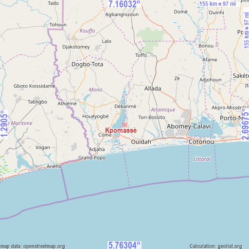
Kpomassè GPS coordinates[2]
6° 27' 43.776" North, 1° 59' 37.032" East
| Map corner | latitude | longitude |
|---|---|---|
| Upper-left | 7.16032°, | 1.2905° |
| Center: | 6.46216°, | 1.99362° |
| Lower-right: | 5.76304°, | 2.69675° |
| Map W x H: | 155.4×155.4 km | = 96.6×96.6mi |
| max Lat: | 11.86819° ⇑82.6% North |
| Kpomassè: | 6.46216° |
| min Lat: | ⇓17.4% South 6.28036° |
| min Long | Kpomassè | max Long |
| 1.26651° | 1.99362° | 3.38327° |
| W 26.1%⇐ | ⇒73.9% E |
Elevation
Elevation of Kpomassè is 64 m = 210 ft, and this is 98.8 m = 324 ft below average elevation for this country.
| Max E: |
472 m = 1549 ft | 67.4% |
| Avg. | 162.8 m = 534 ft | |
| Kpomassè | 64 m = 210 ft | |
Min E: |
1 m = 3 ft | 32.6% |
See also: Benin elevation on elevation.city.
Geographical zone
Kpomassè is located in North Torrid zone (between Equator and Tropic of Cancer). Distance of Equator is 718.5 km =446.5 mi to South.| Distance of | km | miles | from Kpomassè |
|---|---|---|---|
| North Pole | 9288.5 | 5771.6 | to North |
| Arctic Circle | 6682.6 | 4152.4 | to North |
| Tropic Cancer | 1887.4 | 1172.8 | to North |
| Equator | 718.5 | 446.5 | to South |


Nearby cities:
15 places around Kpomassè: (largest is in red/bold)
• Abomey-Calavi
40 km =24.9 mi,  92°
92°
• Adjohon
60.6 km =37.7 mi,  61°
61°
• Allada
28.5 km =17.7 mi,  37°
37°
• Avakpa
22.9 km =14.2 mi,  13°
13°
• Comé
13.7 km =8.5 mi,  243°
243°
• Cotonou
48.1 km =29.9 mi,  102°
102°
• Dogbo
44.2 km =27.5 mi,  327°
327°
• Grand-Popo
27.7 km =17.2 mi,  223°
223°
• Hinvi
38.9 km =24.2 mi,  29°
29°
• Hévié
28.8 km =17.9 mi, 100°
• Lokossa
36.3 km =22.6 mi,  302°
302°
• Ouidah
14.9 km =9.3 mi,  137°
137°
• Pahou
25.7 km =16 mi,  108°
108°
• So-Ava
45.2 km =28.1 mi, 85°
• Sé
34.6 km =21.5 mi,  20°
20°
Sources, notices
• [Note1] Compared only with cities in Benin existing in our database
• [Src1] Map data: © OpenStreetMap contributors (CC-BY-SA)
• [Src2] Other city data from geonames.org with taken over terms of usage.
• [Src3] Geographical zone / Annual Mean Temperature by Robert A. Rohde @ Wikipedia
