Punata geodata
Punata (Cochabamba) is a populated place; located in Bolivia in America/La_Paz (GMT-4) time zone. With population of 15,194 people, there are 32 cities with bigger population in this country. Compared to other cities in Bolivia, 63.4% of cities are located further ↓South; 64% of cities are located further →East and 62.1% of cities have lower elevation than Punata. Note1


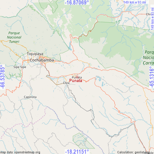
Punata GPS coordinates[2]
17° 32' 32.424" South, 65° 50' 4.992" West
| Map corner | latitude | longitude |
|---|---|---|
| Upper-left | -16.87069°, | -66.53785° |
| Center: | -17.54234°, | -65.83472° |
| Lower-right: | -18.21151°, | -65.1316° |
| Map W x H: | 149.1×149.1 km | = 92.6×92.6mi |
| max Lat: | -9.71828° ⇑36.6% North |
| Punata: | -17.54234° |
| min Lat: | ⇓63.4% South -22.73206° |
| min Long | Punata | max Long |
| -69.14843° | -65.83472° | -57.76667° |
| W 36%⇐ | ⇒64% E |
Elevation
Elevation of Punata is 2731 m = 8960 ft, and this is 719.7 m = 2361 ft above average elevation for this country.
| Max E: |
4732 m = 15525 ft | 37.9% |
| Punata | 2731 m 8960 ft | |
| Avg. | 2011.3 m = 6599 ft | |
Min E: |
92 m = 302 ft | 62.1% |
See also: Bolivia elevation on elevation.city.
Geographical zone
Punata is located in South Torrid zone (between Equator and Tropic of Capricorn). Distance of this Southern Tropic circle is 655.4 km =407.2 mi to South.| Distance of | km | miles | from Punata |
|---|---|---|---|
| Equator | 1950.5 | 1212 | to North |
| Tropic Capricorn | 655.4 | 407.2 | to South |
| Antarctic Circle | 5450.6 | 3386.8 | to South |
| South Pole | 8056.5 | 5006.1 | to South |


Nearby cities:
15 places around Punata: (largest is in red/bold)
• Arani
7.6 km =4.7 mi,  112°
112°
• Capinota
48.9 km =30.4 mi,  247°
247°
• Cañada Hornillos
75.4 km =46.9 mi,  102°
102°
• Chimoré
94.6 km =58.8 mi,  49°
49°
• Cliza
11.5 km =7.1 mi,  244°
244°
• Cochabamba
38.2 km =23.7 mi,  296°
296°
• Colomi
21.7 km =13.5 mi,  350°
350°
• Irpa Irpa
49.7 km =30.9 mi, 247°
• Mizque
68.6 km =42.6 mi,  130°
130°
• Quillacollo
49.9 km =31 mi,  289°
289°
• Sacaba
26.9 km =16.7 mi,  306°
306°
• Sipe Sipe
59.1 km =36.7 mi,  280°
280°
• Tarata
21.1 km =13.1 mi, 249°
• Tiquipaya
46.4 km =28.8 mi, 299°
• Totora
71 km =44.1 mi, 106°
Sources, notices
• [Note1] Compared only with cities in Bolivia existing in our database
• [Src1] Map data: © OpenStreetMap contributors (CC-BY-SA)
• [Src2] Other city data from geonames.org with taken over terms of usage.
• [Src3] Geographical zone / Annual Mean Temperature by Robert A. Rohde @ Wikipedia
