Pedra Branca geodata
Pedra Branca (Ceará) is a populated place; located in Brazil in America/Fortaleza (GMT-3) time zone. With population of 20,072 people, there are 937 cities with bigger population in this country. Compared to other cities in Brazil, 87.4% of cities are located further ↓South; 76.5% of cities are located further ←West and 62.8% of cities have lower elevation than Pedra Branca. Note1


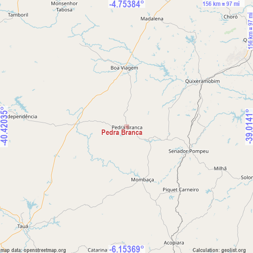
Pedra Branca GPS coordinates[2]
5° 27' 15.012" South, 39° 43' 1.992" West
| Map corner | latitude | longitude |
|---|---|---|
| Upper-left | -4.75384°, | -40.42035° |
| Center: | -5.45417°, | -39.71722° |
| Lower-right: | -6.15369°, | -39.0141° |
| Map W x H: | 155.6×155.7 km | = 96.7×96.7mi |
| max Lat: | 2.81972° ⇑12.6% North |
| Pedra Branca: | -5.45417° |
| min Lat: | ⇓87.4% South -33.69111° |
| min Long | Pedra Branca | max Long |
| -72.89583° | -39.71722° | -32.41083° |
| W 76.5%⇐ | ⇒23.5% E |
Elevation
Elevation of Pedra Branca is 506 m = 1660 ft, and this is 125.1 m = 410 ft above average elevation for this country.
| Max E: |
1603 m = 5259 ft | 37.2% |
| Pedra Branca | 506 m 1660 ft | |
| Avg. | 380.9 m = 1250 ft | |
Min E: |
0 m = 0 ft | 62.8% |
See also: Brazil elevation on elevation.city.
Geographical zone
Pedra Branca is located in South Torrid zone (between Equator and Tropic of Capricorn). Distance of Equator is 606.4 km =376.8 mi to North.| Distance of | km | miles | from Pedra Branca |
|---|---|---|---|
| Equator | 606.4 | 376.8 | to North |
| Tropic Capricorn | 1999.5 | 1242.4 | to South |
| Antarctic Circle | 6794.7 | 4222 | to South |
| South Pole | 9400.6 | 5841.3 | to South |


Nearby cities:
15 places around Pedra Branca: (largest is in red/bold)
• Acopiara
77.1 km =47.9 mi,  157°
157°
• Boa Viagem
36.4 km =22.6 mi,  357°
357°
• Crateús
110.6 km =68.7 mi,  286°
286°
• Iguatu
110.8 km =68.8 mi, 155°
• Independência
65.8 km =40.9 mi,  275°
275°
• Jucás
120.9 km =75.1 mi,  170°
170°
• Mombaça
33.6 km =20.9 mi, 162°
• Novo Oriente
117.3 km =72.9 mi,  265°
265°
• Orós
125 km =77.7 mi,  134°
134°
• Quixadá
94.5 km =58.7 mi,  55°
55°
• Quixeramobim
54.9 km =34.1 mi, 58°
• Senador Pompeu
41 km =25.5 mi,  111°
111°
• São João dos Inhamuns
87.2 km =54.2 mi,  225°
225°
• Tamboril
96.2 km =59.8 mi,  315°
315°
• Várzea Alegre
74.6 km =46.4 mi, 278°
Sources, notices
• [Note1] Compared only with cities in Brazil existing in our database
• [Src1] Map data: © OpenStreetMap contributors (CC-BY-SA)
• [Src2] Other city data from geonames.org with taken over terms of usage.
• [Src3] Geographical zone / Annual Mean Temperature by Robert A. Rohde @ Wikipedia
