Prainha geodata
Prainha (Pará) is a populated place; located in Brazil in America/Santarem (GMT-3) time zone. With population of 6,481 people, there are 1856 cities with bigger population in this country. Compared to other cities in Brazil, 97.8% of cities are located further ↓South; 91.5% of cities are located further →East and 83.5% of cities have higher elevation than Prainha. Note1


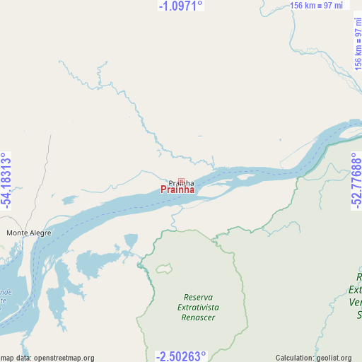
Prainha GPS coordinates[2]
1° 48' 0" South, 53° 28' 48" West
| Map corner | latitude | longitude |
|---|---|---|
| Upper-left | -1.0971°, | -54.18313° |
| Center: | -1.8°, | -53.48° |
| Lower-right: | -2.50263°, | -52.77688° |
| Map W x H: | 156.3×156.3 km | = 97.1×97.1mi |
| max Lat: | 2.81972° ⇑2.2% North |
| Prainha: | -1.8° |
| min Lat: | ⇓97.8% South -33.69111° |
| min Long | Prainha | max Long |
| -72.89583° | -53.48° | -32.41083° |
| W 8.5%⇐ | ⇒91.5% E |
Elevation
Elevation of Prainha is 35 m = 115 ft, and this is 345.9 m = 1135 ft below average elevation for this country.
| Max E: |
1603 m = 5259 ft | 83.5% |
| Avg. | 380.9 m = 1250 ft | |
| Prainha | 35 m = 115 ft | |
Min E: |
0 m = 0 ft | 16.5% |
See also: Brazil elevation on elevation.city.
Geographical zone
Prainha is located in South Torrid zone (between Equator and Tropic of Capricorn). Distance of Equator is 200.1 km =124.3 mi to North.| Distance of | km | miles | from Prainha |
|---|---|---|---|
| Equator | 200.1 | 124.3 | to North |
| Tropic Capricorn | 2405.8 | 1494.9 | to South |
| Antarctic Circle | 7201 | 4474.5 | to South |
| South Pole | 9806.9 | 6093.7 | to South |


Nearby cities:
15 places around Prainha: (largest is in red/bold)
• Alenquer
140.7 km =87.4 mi,  263°
263°
• Almeirim
104.5 km =64.9 mi,  72°
72°
• Altamira
210.6 km =130.9 mi,  137°
137°
• Breves
333.6 km =207.3 mi,  87°
87°
• Gurupá
209.2 km =130 mi,  77°
77°
• Juruti
292.9 km =182 mi, 262°
• Mazagão
307.3 km =190.9 mi,  52°
52°
• Monte Alegre
70.4 km =43.7 mi,  251°
251°
• Oriximiná
265.2 km =164.8 mi,  270°
270°
• Portel
295.9 km =183.9 mi, 92°
• Porto de Moz
138.1 km =85.8 mi, 87°
• Santana
320.6 km =199.2 mi, 52°
• Santarém
154.1 km =95.8 mi,  242°
242°
• Senador José Porfírio
191 km =118.7 mi,  117°
117°
• Óbidos
226.9 km =141 mi, 266°
Sources, notices
• [Note1] Compared only with cities in Brazil existing in our database
• [Src1] Map data: © OpenStreetMap contributors (CC-BY-SA)
• [Src2] Other city data from geonames.org with taken over terms of usage.
• [Src3] Geographical zone / Annual Mean Temperature by Robert A. Rohde @ Wikipedia
