Manaíra geodata
Manaíra (Paraíba) is a populated place; located in Brazil in America/Fortaleza (GMT-3) time zone. With population of 4,913 people, there are 1923 cities with bigger population in this country. Compared to other cities in Brazil, 76.5% of cities are located further ↓South; 83.9% of cities are located further ←West and 84.9% of cities have lower elevation than Manaíra. Note1


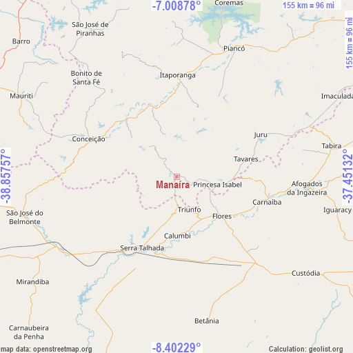
Manaíra GPS coordinates[2]
7° 42' 21.996" South, 38° 9' 15.984" West
| Map corner | latitude | longitude |
|---|---|---|
| Upper-left | -7.00878°, | -38.85757° |
| Center: | -7.70611°, | -38.15444° |
| Lower-right: | -8.40229°, | -37.45132° |
| Map W x H: | 154.9×154.9 km | = 96.3×96.3mi |
| max Lat: | 2.81972° ⇑23.5% North |
| Manaíra: | -7.70611° |
| min Lat: | ⇓76.5% South -33.69111° |
| min Long | Manaíra | max Long |
| -72.89583° | -38.15444° | -32.41083° |
| W 83.9%⇐ | ⇒16.1% E |
Elevation
Elevation of Manaíra is 758 m = 2487 ft, and this is 377.1 m = 1237 ft above average elevation for this country.
| Max E: |
1603 m = 5259 ft | 15.1% |
| Manaíra | 758 m 2487 ft | |
| Avg. | 380.9 m = 1250 ft | |
Min E: |
0 m = 0 ft | 84.9% |
See also: Brazil elevation on elevation.city.
Geographical zone
Manaíra is located in South Torrid zone (between Equator and Tropic of Capricorn). Distance of Equator is 856.8 km =532.4 mi to North.| Distance of | km | miles | from Manaíra |
|---|---|---|---|
| Equator | 856.8 | 532.4 | to North |
| Tropic Capricorn | 1749.1 | 1086.8 | to South |
| Antarctic Circle | 6544.3 | 4066.4 | to South |
| South Pole | 9150.2 | 5685.7 | to South |


Nearby cities:
15 places around Manaíra: (largest is in red/bold)
• Afogados da Ingazeira
57 km =35.4 mi,  95°
95°
• Brejo Santo
94.8 km =58.9 mi,  284°
284°
• Coremas
80.3 km =49.9 mi,  16°
16°
• Custódia
70.5 km =43.8 mi,  126°
126°
• Flores
26.8 km =16.7 mi, 132°
• Imaculada
79.3 km =49.3 mi,  63°
63°
• Itaporanga
44.7 km =27.8 mi,  0°
0°
• Juru
41.5 km =25.8 mi, 63°
• Piancó
61.7 km =38.3 mi, 23°
• Princesa Isabel
18.1 km =11.2 mi, 100°
• Serra Talhada
35.5 km =22.1 mi,  206°
206°
• São José de Piranhas
75.5 km =46.9 mi,  329°
329°
• São José do Belmonte
68.9 km =42.8 mi,  255°
255°
• Tabira
69 km =42.9 mi,  79°
79°
• Tavares
31.4 km =19.5 mi, 75°
Sources, notices
• [Note1] Compared only with cities in Brazil existing in our database
• [Src1] Map data: © OpenStreetMap contributors (CC-BY-SA)
• [Src2] Other city data from geonames.org with taken over terms of usage.
• [Src3] Geographical zone / Annual Mean Temperature by Robert A. Rohde @ Wikipedia
