Acopiara geodata
Acopiara (Ceará) is a populated place; located in Brazil in America/Fortaleza (GMT-3) time zone. With population of 24,561 people, there are 793 cities with bigger population in this country. Compared to other cities in Brazil, 84.9% of cities are located further ↓South; 77.6% of cities are located further ←West and 52.3% of cities have higher elevation than Acopiara. Note1


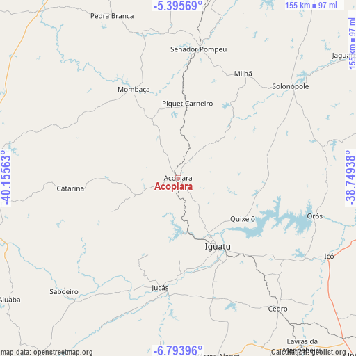
Acopiara GPS coordinates[2]
6° 5' 43.008" South, 39° 27' 9" West
| Map corner | latitude | longitude |
|---|---|---|
| Upper-left | -5.39569°, | -40.15563° |
| Center: | -6.09528°, | -39.4525° |
| Lower-right: | -6.79396°, | -38.74938° |
| Map W x H: | 155.5×155.5 km | = 96.6×96.6mi |
| max Lat: | 2.81972° ⇑15.1% North |
| Acopiara: | -6.09528° |
| min Lat: | ⇓84.9% South -33.69111° |
| min Long | Acopiara | max Long |
| -72.89583° | -39.4525° | -32.41083° |
| W 77.6%⇐ | ⇒22.4% E |
Elevation
Elevation of Acopiara is 319 m = 1047 ft, and this is 61.9 m = 203 ft below average elevation for this country.
| Max E: |
1603 m = 5259 ft | 52.3% |
| Avg. | 380.9 m = 1250 ft | |
| Acopiara | 319 m = 1047 ft | |
Min E: |
0 m = 0 ft | 47.7% |
See also: Brazil elevation on elevation.city.
Geographical zone
Acopiara is located in South Torrid zone (between Equator and Tropic of Capricorn). Distance of Equator is 677.7 km =421.1 mi to North.| Distance of | km | miles | from Acopiara |
|---|---|---|---|
| Equator | 677.7 | 421.1 | to North |
| Tropic Capricorn | 1928.2 | 1198.1 | to South |
| Antarctic Circle | 6723.4 | 4177.7 | to South |
| South Pole | 9329.3 | 5797 | to South |


Nearby cities:
15 places around Acopiara: (largest is in red/bold)
• Assaré
98.4 km =61.1 mi,  208°
208°
• Barro
94.7 km =58.8 mi,  136°
136°
• Cedro
71.4 km =44.4 mi, 142°
• Farias Brito
93.7 km =58.2 mi,  187°
187°
• Icó
73.6 km =45.7 mi,  117°
117°
• Iguatu
33.9 km =21.1 mi,  149°
149°
• Jaguaribe
94.6 km =58.8 mi,  76°
76°
• Jucás
48.5 km =30.1 mi, 189°
• Lavras da Mangabeira
90.9 km =56.5 mi, 143°
• Mombaça
43.7 km =27.2 mi,  333°
333°
• Orós
61.8 km =38.4 mi,  105°
105°
• Pedra Branca
77.1 km =47.9 mi,  337°
337°
• Quixeramobim
101.2 km =62.9 mi,  10°
10°
• Senador Pompeu
57.1 km =35.5 mi, 9°
• São João dos Inhamuns
92.5 km =57.5 mi,  276°
276°
Sources, notices
• [Note1] Compared only with cities in Brazil existing in our database
• [Src1] Map data: © OpenStreetMap contributors (CC-BY-SA)
• [Src2] Other city data from geonames.org with taken over terms of usage.
• [Src3] Geographical zone / Annual Mean Temperature by Robert A. Rohde @ Wikipedia
