Custódia geodata
Custódia (Pernambuco) is a populated place; located in Brazil in America/Recife (GMT-3) time zone. With population of 18,107 people, there are 1038 cities with bigger population in this country. Compared to other cities in Brazil, 74.6% of cities are located further ↓South; 86% of cities are located further ←West and 66.5% of cities have lower elevation than Custódia. Note1


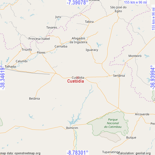
Custódia GPS coordinates[2]
8° 5' 15" South, 37° 38' 35.016" West
| Map corner | latitude | longitude |
|---|---|---|
| Upper-left | -7.39078°, | -38.34619° |
| Center: | -8.0875°, | -37.64306° |
| Lower-right: | -8.78301°, | -36.93994° |
| Map W x H: | 154.8×154.8 km | = 96.2×96.2mi |
| max Lat: | 2.81972° ⇑25.4% North |
| Custódia: | -8.0875° |
| min Lat: | ⇓74.6% South -33.69111° |
| min Long | Custódia | max Long |
| -72.89583° | -37.64306° | -32.41083° |
| W 86%⇐ | ⇒14% E |
Elevation
Elevation of Custódia is 540 m = 1772 ft, and this is 159.1 m = 522 ft above average elevation for this country.
| Max E: |
1603 m = 5259 ft | 33.5% |
| Custódia | 540 m 1772 ft | |
| Avg. | 380.9 m = 1250 ft | |
Min E: |
0 m = 0 ft | 66.5% |
See also: Brazil elevation on elevation.city.
Geographical zone
Custódia is located in South Torrid zone (between Equator and Tropic of Capricorn). Distance of Equator is 899.2 km =558.7 mi to North.| Distance of | km | miles | from Custódia |
|---|---|---|---|
| Equator | 899.2 | 558.7 | to North |
| Tropic Capricorn | 1706.7 | 1060.5 | to South |
| Antarctic Circle | 6501.9 | 4040.1 | to South |
| South Pole | 9107.8 | 5659.3 | to South |


Nearby cities:
15 places around Custódia: (largest is in red/bold)
• Afogados da Ingazeira
37.4 km =23.2 mi,  0°
0°
• Arcoverde
74.6 km =46.4 mi,  119°
119°
• Carnaíba
68.2 km =42.4 mi,  182°
182°
• Flores
43.9 km =27.3 mi,  303°
303°
• Ibimirim
50.6 km =31.4 mi,  185°
185°
• Imaculada
79 km =49.1 mi,  10°
10°
• Juru
64.2 km =39.9 mi,  342°
342°
• Manaíra
70.5 km =43.8 mi,  306°
306°
• Monteiro
61.7 km =38.3 mi,  69°
69°
• Princesa Isabel
54.9 km =34.1 mi,  315°
315°
• Serra Talhada
72.9 km =45.3 mi,  278°
278°
• Sertânia
41.7 km =25.9 mi,  87°
87°
• São José do Egito
78.9 km =49 mi,  30°
30°
• Tabira
56.4 km =35 mi, 11°
• Tavares
56.5 km =35.1 mi,  332°
332°
Sources, notices
• [Note1] Compared only with cities in Brazil existing in our database
• [Src1] Map data: © OpenStreetMap contributors (CC-BY-SA)
• [Src2] Other city data from geonames.org with taken over terms of usage.
• [Src3] Geographical zone / Annual Mean Temperature by Robert A. Rohde @ Wikipedia
