Coelho Neto geodata
Coelho Neto (Maranhão) is a populated place; located in Brazil in America/Fortaleza (GMT-3) time zone. With population of 36,184 people, there are 567 cities with bigger population in this country. Compared to other cities in Brazil, 90.4% of cities are located further ↓South; 60.3% of cities are located further ←West and 78.7% of cities have higher elevation than Coelho Neto. Note1


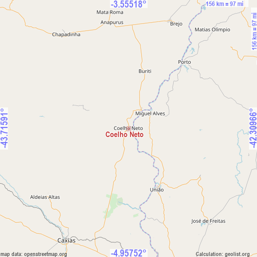
Coelho Neto GPS coordinates[2]
4° 15' 24.012" South, 43° 0' 46.008" West
| Map corner | latitude | longitude |
|---|---|---|
| Upper-left | -3.55518°, | -43.71591° |
| Center: | -4.25667°, | -43.01278° |
| Lower-right: | -4.95752°, | -42.30966° |
| Map W x H: | 155.9×155.9 km | = 96.9×96.9mi |
| max Lat: | 2.81972° ⇑9.6% North |
| Coelho Neto: | -4.25667° |
| min Lat: | ⇓90.4% South -33.69111° |
| min Long | Coelho Neto | max Long |
| -72.89583° | -43.01278° | -32.41083° |
| W 60.3%⇐ | ⇒39.7% E |
Elevation
Elevation of Coelho Neto is 54 m = 177 ft, and this is 326.9 m = 1073 ft below average elevation for this country.
| Max E: |
1603 m = 5259 ft | 78.7% |
| Avg. | 380.9 m = 1250 ft | |
| Coelho Neto | 54 m = 177 ft | |
Min E: |
0 m = 0 ft | 21.3% |
See also: Brazil elevation on elevation.city.
Geographical zone
Coelho Neto is located in South Torrid zone (between Equator and Tropic of Capricorn). Distance of Equator is 473.3 km =294.1 mi to North.| Distance of | km | miles | from Coelho Neto |
|---|---|---|---|
| Equator | 473.3 | 294.1 | to North |
| Tropic Capricorn | 2132.6 | 1325.1 | to South |
| Antarctic Circle | 6927.9 | 4304.8 | to South |
| South Pole | 9533.8 | 5924 | to South |


Nearby cities:
15 places around Coelho Neto: (largest is in red/bold)
• Barras
79.7 km =49.5 mi,  89°
89°
• Brejo
70 km =43.5 mi,  24°
24°
• Caxias
77 km =47.8 mi,  209°
209°
• Chapadinha
69 km =42.9 mi,  326°
326°
• Codó
99.3 km =61.7 mi,  257°
257°
• Esperantina
95 km =59 mi,  65°
65°
• José de Freitas
73.7 km =45.8 mi,  138°
138°
• Matias Olímpio
78.7 km =48.9 mi,  40°
40°
• Miguel Alves
16.5 km =10.3 mi,  52°
52°
• Porto
52.5 km =32.6 mi, 39°
• Santa Quitéria do Maranhão
97.3 km =60.5 mi,  32°
32°
• Teresina
95.5 km =59.3 mi,  165°
165°
• Timbiras
102.9 km =63.9 mi,  270°
270°
• Timon
95.1 km =59.1 mi, 168°
• União
40.1 km =24.9 mi,  155°
155°
Sources, notices
• [Note1] Compared only with cities in Brazil existing in our database
• [Src1] Map data: © OpenStreetMap contributors (CC-BY-SA)
• [Src2] Other city data from geonames.org with taken over terms of usage.
• [Src3] Geographical zone / Annual Mean Temperature by Robert A. Rohde @ Wikipedia
