Caxias geodata
Caxias (Maranhão) is a populated place; located in Brazil in America/Fortaleza (GMT-3) time zone. With population of 148,072 people, there are 155 cities with bigger population in this country. Compared to other cities in Brazil, 89% of cities are located further ↓South; 58.8% of cities are located further ←West and 74.3% of cities have higher elevation than Caxias. Note1


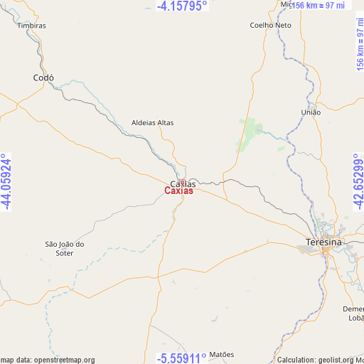
Caxias GPS coordinates[2]
4° 51' 32.004" South, 43° 21' 21.996" West
| Map corner | latitude | longitude |
|---|---|---|
| Upper-left | -4.15795°, | -44.05924° |
| Center: | -4.85889°, | -43.35611° |
| Lower-right: | -5.55911°, | -42.65299° |
| Map W x H: | 155.8×155.8 km | = 96.8×96.8mi |
| max Lat: | 2.81972° ⇑11% North |
| Caxias: | -4.85889° |
| min Lat: | ⇓89% South -33.69111° |
| min Long | Caxias | max Long |
| -72.89583° | -43.35611° | -32.41083° |
| W 58.8%⇐ | ⇒41.2% E |
Elevation
Elevation of Caxias is 83 m = 272 ft, and this is 297.9 m = 977 ft below average elevation for this country.
| Max E: |
1603 m = 5259 ft | 74.3% |
| Avg. | 380.9 m = 1250 ft | |
| Caxias | 83 m = 272 ft | |
Min E: |
0 m = 0 ft | 25.7% |
See also: Caxias elevation on elevation.city.
Geographical zone
Caxias is located in South Torrid zone (between Equator and Tropic of Capricorn). Distance of Equator is 540.3 km =335.7 mi to North.| Distance of | km | miles | from Caxias |
|---|---|---|---|
| Equator | 540.3 | 335.7 | to North |
| Tropic Capricorn | 2065.7 | 1283.6 | to South |
| Antarctic Circle | 6860.9 | 4263.2 | to South |
| South Pole | 9466.8 | 5882.4 | to South |


Nearby cities:
15 places around Caxias: (largest is in red/bold)
• Altos
101.2 km =62.9 mi,  101°
101°
• Buriti Bravo
120.9 km =75.1 mi,  205°
205°
• Codó
73.9 km =45.9 mi,  307°
307°
• Coelho Neto
77 km =47.8 mi,  29°
29°
• Coroatá
117.5 km =73 mi, 313°
• Demerval Lobão
93.5 km =58.1 mi,  126°
126°
• Estreito
103.5 km =64.3 mi,  173°
173°
• José de Freitas
87.2 km =54.2 mi,  82°
82°
• Miguel Alves
92.5 km =57.5 mi, 33°
• Monsenhor Gil
114.1 km =70.9 mi, 133°
• Parnarama
96 km =59.7 mi,  162°
162°
• Teresina
66.5 km =41.3 mi,  112°
112°
• Timbiras
93.3 km =58 mi,  316°
316°
• Timon
63.2 km =39.3 mi, 114°
• União
62.4 km =38.8 mi,  60°
60°
Sources, notices
• [Note1] Compared only with cities in Brazil existing in our database
• [Src1] Map data: © OpenStreetMap contributors (CC-BY-SA)
• [Src2] Other city data from geonames.org with taken over terms of usage.
• [Src3] Geographical zone / Annual Mean Temperature by Robert A. Rohde @ Wikipedia
