Balsas geodata
Balsas (Maranhão) is a populated place; located in Brazil in America/Fortaleza (GMT-3) time zone. With population of 68,056 people, there are 332 cities with bigger population in this country. Compared to other cities in Brazil, 77.5% of cities are located further ↓South; 52.5% of cities are located further →East and 56% of cities have higher elevation than Balsas. Note1


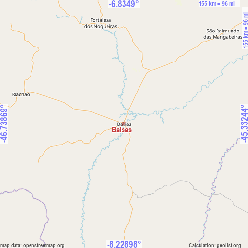
Balsas GPS coordinates[2]
7° 31' 57" South, 46° 2' 8.016" West
| Map corner | latitude | longitude |
|---|---|---|
| Upper-left | -6.8349°, | -46.73869° |
| Center: | -7.5325°, | -46.03556° |
| Lower-right: | -8.22898°, | -45.33244° |
| Map W x H: | 155×155 km | = 96.3×96.3mi |
| max Lat: | 2.81972° ⇑22.5% North |
| Balsas: | -7.5325° |
| min Lat: | ⇓77.5% South -33.69111° |
| min Long | Balsas | max Long |
| -72.89583° | -46.03556° | -32.41083° |
| W 47.5%⇐ | ⇒52.5% E |
Elevation
Elevation of Balsas is 254 m = 833 ft, and this is 126.9 m = 416 ft below average elevation for this country.
| Max E: |
1603 m = 5259 ft | 56% |
| Avg. | 380.9 m = 1250 ft | |
| Balsas | 254 m = 833 ft | |
Min E: |
0 m = 0 ft | 44% |
See also: Balsas elevation on elevation.city.
Geographical zone
Balsas is located in South Torrid zone (between Equator and Tropic of Capricorn). Distance of Equator is 837.5 km =520.4 mi to North.| Distance of | km | miles | from Balsas |
|---|---|---|---|
| Equator | 837.5 | 520.4 | to North |
| Tropic Capricorn | 1768.4 | 1098.8 | to South |
| Antarctic Circle | 6563.6 | 4078.4 | to South |
| South Pole | 9169.5 | 5697.7 | to South |


Nearby cities:
15 places around Balsas: (largest is in red/bold)
• Amarante do Maranhão
232.1 km =144.2 mi,  340°
340°
• Barra do Corda
241.8 km =150.2 mi,  21°
21°
• Bom Jardim
75.7 km =47 mi,  319°
319°
• Carolina
158.8 km =98.7 mi,  277°
277°
• Grajaú
190.8 km =118.6 mi,  356°
356°
• Mirador
225.3 km =140 mi,  55°
55°
• Montes Altos
220.6 km =137.1 mi,  328°
328°
• Morros
214.8 km =133.5 mi,  187°
187°
• Pastos Bons
239.7 km =148.9 mi, 64°
• Porto Franco
200.7 km =124.7 mi,  311°
311°
• Raposa
233.5 km =145.1 mi, 61°
• Riachão
66.9 km =41.6 mi,  286°
286°
• Santa Luzia
130.8 km =81.3 mi,  264°
264°
• São Raimundo das Mangabeiras
83.4 km =51.8 mi,  47°
47°
• Uruçuí
166.6 km =103.5 mi,  78°
78°
Sources, notices
• [Note1] Compared only with cities in Brazil existing in our database
• [Src1] Map data: © OpenStreetMap contributors (CC-BY-SA)
• [Src2] Other city data from geonames.org with taken over terms of usage.
• [Src3] Geographical zone / Annual Mean Temperature by Robert A. Rohde @ Wikipedia
