Montes Altos geodata
Montes Altos (Maranhão) is a populated place; located in Brazil in America/Fortaleza (GMT-3) time zone. With population of 3,518 people, there are 1978 cities with bigger population in this country. Compared to other cities in Brazil, 85.8% of cities are located further ↓South; 59.1% of cities are located further →East and 57.2% of cities have higher elevation than Montes Altos. Note1


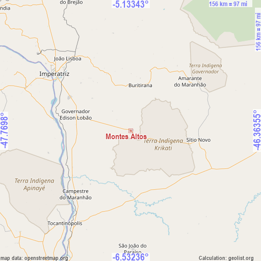
Montes Altos GPS coordinates[2]
5° 49' 59.988" South, 47° 4' 0.012" West
| Map corner | latitude | longitude |
|---|---|---|
| Upper-left | -5.13343°, | -47.7698° |
| Center: | -5.83333°, | -47.06667° |
| Lower-right: | -6.53236°, | -46.36355° |
| Map W x H: | 155.5×155.6 km | = 96.6×96.7mi |
| max Lat: | 2.81972° ⇑14.2% North |
| Montes Altos: | -5.83333° |
| min Lat: | ⇓85.8% South -33.69111° |
| min Long | Montes Altos | max Long |
| -72.89583° | -47.06667° | -32.41083° |
| W 40.9%⇐ | ⇒59.1% E |
Elevation
Elevation of Montes Altos is 242 m = 794 ft, and this is 138.9 m = 456 ft below average elevation for this country.
| Max E: |
1603 m = 5259 ft | 57.2% |
| Avg. | 380.9 m = 1250 ft | |
| Montes Altos | 242 m = 794 ft | |
Min E: |
0 m = 0 ft | 42.8% |
See also: Brazil elevation on elevation.city.
Geographical zone
Montes Altos is located in South Torrid zone (between Equator and Tropic of Capricorn). Distance of Equator is 648.6 km =403 mi to North.| Distance of | km | miles | from Montes Altos |
|---|---|---|---|
| Equator | 648.6 | 403 | to North |
| Tropic Capricorn | 1957.3 | 1216.2 | to South |
| Antarctic Circle | 6752.6 | 4195.9 | to South |
| South Pole | 9358.5 | 5815.1 | to South |


Nearby cities:
15 places around Montes Altos: (largest is in red/bold)
• Amarante do Maranhão
46.6 km =29 mi,  50°
50°
• Araguaína
196.6 km =122.2 mi,  219°
219°
• Balsas
220.6 km =137.1 mi,  148°
148°
• Barra do Corda
205 km =127.4 mi,  79°
79°
• Bom Jardim
146.5 km =91 mi, 153°
• Carolina
172.7 km =107.3 mi,  194°
194°
• Grajaú
102.7 km =63.8 mi,  89°
89°
• Imperatriz
58.1 km =36.1 mi,  305°
305°
• Marabá
234 km =145.4 mi,  282°
282°
• Paulo Ramos
254.5 km =158.1 mi, 52°
• Porto Franco
67.1 km =41.7 mi,  213°
213°
• Riachão
177.1 km =110 mi,  163°
163°
• Santa Luzia
201.9 km =125.5 mi,  184°
184°
• São Geraldo do Araguaia
176.2 km =109.5 mi,  249°
249°
• São Raimundo das Mangabeiras
219.4 km =136.3 mi,  127°
127°
Sources, notices
• [Note1] Compared only with cities in Brazil existing in our database
• [Src1] Map data: © OpenStreetMap contributors (CC-BY-SA)
• [Src2] Other city data from geonames.org with taken over terms of usage.
• [Src3] Geographical zone / Annual Mean Temperature by Robert A. Rohde @ Wikipedia
