Amarante do Maranhão geodata
Amarante do Maranhão (Maranhão) is a populated place; located in Brazil in America/Fortaleza (GMT-3) time zone. With population of 11,510 people, there are 1523 cities with bigger population in this country. Compared to other cities in Brazil, 86.9% of cities are located further ↓South; 56.5% of cities are located further →East and 56.8% of cities have higher elevation than Amarante do Maranhão. Note1


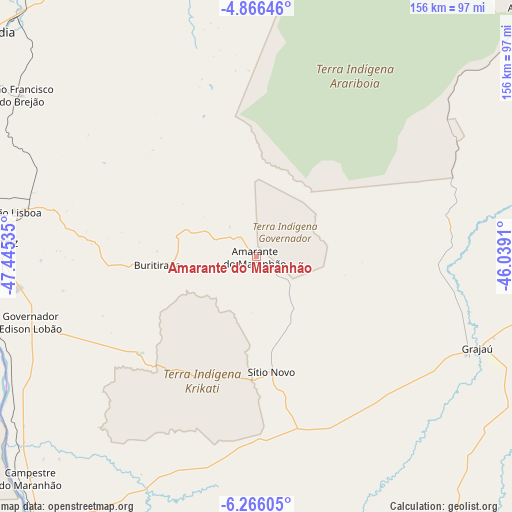
Amarante do Maranhão GPS coordinates[2]
5° 34' 0.012" South, 46° 44' 31.992" West
| Map corner | latitude | longitude |
|---|---|---|
| Upper-left | -4.86646°, | -47.44535° |
| Center: | -5.56667°, | -46.74222° |
| Lower-right: | -6.26605°, | -46.0391° |
| Map W x H: | 155.6×155.6 km | = 96.7×96.7mi |
| max Lat: | 2.81972° ⇑13.1% North |
| Amarante do Maranhão: | -5.56667° |
| min Lat: | ⇓86.9% South -33.69111° |
| min Long | Amarante do Mar | max Long |
| -72.89583° | -46.74222° | -32.41083° |
| W 43.5%⇐ | ⇒56.5% E |
Elevation
Elevation of Amarante do Maranhão is 247 m = 810 ft, and this is 133.9 m = 439 ft below average elevation for this country.
| Max E: |
1603 m = 5259 ft | 56.8% |
| Avg. | 380.9 m = 1250 ft | |
| Amarante do Maranhão | 247 m = 810 ft | |
Min E: |
0 m = 0 ft | 43.2% |
See also: Brazil elevation on elevation.city.
Geographical zone
Amarante do Maranhão is located in South Torrid zone (between Equator and Tropic of Capricorn). Distance of Equator is 619 km =384.6 mi to North.| Distance of | km | miles | from Amarante do Maranhão |
|---|---|---|---|
| Equator | 619 | 384.6 | to North |
| Tropic Capricorn | 1987 | 1234.7 | to South |
| Antarctic Circle | 6782.2 | 4214.3 | to South |
| South Pole | 9388.1 | 5833.5 | to South |


Nearby cities:
15 places around Amarante do Maranhão: (largest is in red/bold)
• Balsas
232.1 km =144.2 mi,  160°
160°
• Barra do Corda
166 km =103.1 mi,  87°
87°
• Bom Jardim
163.7 km =101.7 mi,  169°
169°
• Carolina
212.2 km =131.9 mi,  202°
202°
• Grajaú
72.5 km =45 mi,  112°
112°
• Imperatriz
83.1 km =51.6 mi,  273°
273°
• Lago da Pedra
219.1 km =136.1 mi,  49°
49°
• Lago dos Rodrigues
222.1 km =138 mi,  61°
61°
• Montes Altos
46.6 km =29 mi,  230°
230°
• Paulo Ramos
208 km =129.2 mi, 53°
• Paulo Ramos
228.8 km =142.2 mi, 49°
• Porto Franco
112.4 km =69.8 mi,  220°
220°
• Riachão
200.1 km =124.3 mi,  176°
176°
• São Geraldo do Araguaia
220.9 km =137.3 mi,  245°
245°
• São Raimundo das Mangabeiras
213.6 km =132.7 mi,  139°
139°
Sources, notices
• [Note1] Compared only with cities in Brazil existing in our database
• [Src1] Map data: © OpenStreetMap contributors (CC-BY-SA)
• [Src2] Other city data from geonames.org with taken over terms of usage.
• [Src3] Geographical zone / Annual Mean Temperature by Robert A. Rohde @ Wikipedia
