Grajaú geodata
Grajaú (Maranhão) is a populated place; located in Brazil in America/Fortaleza (GMT-3) time zone. With population of 30,217 people, there are 666 cities with bigger population in this country. Compared to other cities in Brazil, 85.9% of cities are located further ↓South; 52.9% of cities are located further →East and 65.6% of cities have higher elevation than Grajaú. Note1


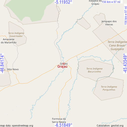
Grajaú GPS coordinates[2]
5° 49' 9.984" South, 46° 8' 18.996" West
| Map corner | latitude | longitude |
|---|---|---|
| Upper-left | -5.11952°, | -46.84174° |
| Center: | -5.81944°, | -46.13861° |
| Lower-right: | -6.51849°, | -45.43549° |
| Map W x H: | 155.6×155.6 km | = 96.7×96.7mi |
| max Lat: | 2.81972° ⇑14.1% North |
| Grajaú: | -5.81944° |
| min Lat: | ⇓85.9% South -33.69111° |
| min Long | Grajaú | max Long |
| -72.89583° | -46.13861° | -32.41083° |
| W 47.1%⇐ | ⇒52.9% E |
Elevation
Elevation of Grajaú is 163 m = 535 ft, and this is 217.9 m = 715 ft below average elevation for this country.
| Max E: |
1603 m = 5259 ft | 65.6% |
| Avg. | 380.9 m = 1250 ft | |
| Grajaú | 163 m = 535 ft | |
Min E: |
0 m = 0 ft | 34.4% |
See also: Brazil elevation on elevation.city.
Geographical zone
Grajaú is located in South Torrid zone (between Equator and Tropic of Capricorn). Distance of Equator is 647.1 km =402.1 mi to North.| Distance of | km | miles | from Grajaú |
|---|---|---|---|
| Equator | 647.1 | 402.1 | to North |
| Tropic Capricorn | 1958.9 | 1217.2 | to South |
| Antarctic Circle | 6754.1 | 4196.8 | to South |
| South Pole | 9360 | 5816 | to South |


Nearby cities:
15 places around Grajaú: (largest is in red/bold)
• Amarante do Maranhão
72.5 km =45 mi,  292°
292°
• Balsas
190.8 km =118.6 mi,  176°
176°
• Barra do Corda
105 km =65.2 mi,  70°
70°
• Bom Jardim
138.5 km =86.1 mi,  195°
195°
• Esperantinópolis
190.5 km =118.4 mi,  56°
56°
• Imperatriz
153.2 km =95.2 mi,  282°
282°
• Lago dos Rodrigues
185.6 km =115.3 mi,  43°
43°
• Montes Altos
102.7 km =63.8 mi,  269°
269°
• Paulo Ramos
182.4 km =113.3 mi,  33°
33°
• Porto Franco
150.8 km =93.7 mi,  247°
247°
• Poção de Pedras
191.8 km =119.2 mi,  48°
48°
• Presidente Dutra
191.7 km =119.1 mi, 72°
• Riachão
179.5 km =111.5 mi, 197°
• São Raimundo das Mangabeiras
152.2 km =94.6 mi,  151°
151°
• Tuntum
176.3 km =109.5 mi, 69°
Sources, notices
• [Note1] Compared only with cities in Brazil existing in our database
• [Src1] Map data: © OpenStreetMap contributors (CC-BY-SA)
• [Src2] Other city data from geonames.org with taken over terms of usage.
• [Src3] Geographical zone / Annual Mean Temperature by Robert A. Rohde @ Wikipedia
