Alto Longá geodata
Alto Longá (Piauí) is a populated place; located in Brazil in America/Fortaleza (GMT-3) time zone. With population of 4,435 people, there are 1947 cities with bigger population in this country. Compared to other cities in Brazil, 87.9% of cities are located further ↓South; 64.9% of cities are located further ←West and 68.1% of cities have higher elevation than Alto Longá. Note1


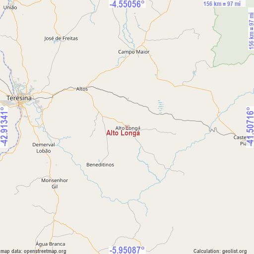
Alto Longá GPS coordinates[2]
5° 15' 3.996" South, 42° 12' 37.008" West
| Map corner | latitude | longitude |
|---|---|---|
| Upper-left | -4.55056°, | -42.91341° |
| Center: | -5.25111°, | -42.21028° |
| Lower-right: | -5.95087°, | -41.50716° |
| Map W x H: | 155.7×155.7 km | = 96.7×96.7mi |
| max Lat: | 2.81972° ⇑12.1% North |
| Alto Longá: | -5.25111° |
| min Lat: | ⇓87.9% South -33.69111° |
| min Long | Alto Longá | max Long |
| -72.89583° | -42.21028° | -32.41083° |
| W 64.9%⇐ | ⇒35.1% E |
Elevation
Elevation of Alto Longá is 141 m = 463 ft, and this is 239.9 m = 787 ft below average elevation for this country.
| Max E: |
1603 m = 5259 ft | 68.1% |
| Avg. | 380.9 m = 1250 ft | |
| Alto Longá | 141 m = 463 ft | |
Min E: |
0 m = 0 ft | 31.9% |
See also: Brazil elevation on elevation.city.
Geographical zone
Alto Longá is located in South Torrid zone (between Equator and Tropic of Capricorn). Distance of Equator is 583.9 km =362.8 mi to North.| Distance of | km | miles | from Alto Longá |
|---|---|---|---|
| Equator | 583.9 | 362.8 | to North |
| Tropic Capricorn | 2022.1 | 1256.5 | to South |
| Antarctic Circle | 6817.3 | 4236.1 | to South |
| South Pole | 9423.2 | 5855.3 | to South |


Nearby cities:
15 places around Alto Longá: (largest is in red/bold)
• Altos
36.4 km =22.6 mi,  310°
310°
• Beneditinos
28.1 km =17.5 mi,  218°
218°
• Campo Maior
47.3 km =29.4 mi,  5°
5°
• Castelo do Piauí
73.3 km =45.5 mi,  96°
96°
• Demerval Lobão
53 km =32.9 mi,  256°
256°
• Elesbão Veloso
106 km =65.9 mi,  175°
175°
• José de Freitas
68.3 km =42.4 mi,  323°
323°
• Monsenhor Gil
56.1 km =34.9 mi,  231°
231°
• Parnarama
108.8 km =67.6 mi,  243°
243°
• São Miguel do Tapuio
102.1 km =63.4 mi,  105°
105°
• São Pedro do Piauí
94.1 km =58.5 mi, 216°
• Teresina
67.9 km =42.2 mi,  285°
285°
• Timon
71.5 km =44.4 mi,  284°
284°
• União
103.5 km =64.3 mi, 315°
• Água Branca
85.5 km =53.1 mi,  213°
213°
Sources, notices
• [Note1] Compared only with cities in Brazil existing in our database
• [Src1] Map data: © OpenStreetMap contributors (CC-BY-SA)
• [Src2] Other city data from geonames.org with taken over terms of usage.
• [Src3] Geographical zone / Annual Mean Temperature by Robert A. Rohde @ Wikipedia
