Teresina geodata
Teresina (Piauí) is a seat of a first-order administrative division; located in Brazil in America/Fortaleza (GMT-3) time zone. With population of 744,512 people, there are 19 cities with bigger population in this country. Compared to other cities in Brazil, 88.6% of cities are located further ↓South; 61.7% of cities are located further ←West and 74.3% of cities have higher elevation than Teresina. Note1


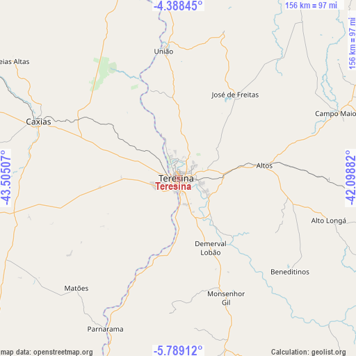
Teresina GPS coordinates[2]
5° 5' 21.012" South, 42° 48' 6.984" West
| Map corner | latitude | longitude |
|---|---|---|
| Upper-left | -4.38845°, | -43.50507° |
| Center: | -5.08917°, | -42.80194° |
| Lower-right: | -5.78912°, | -42.09882° |
| Map W x H: | 155.7×155.7 km | = 96.7×96.7mi |
| max Lat: | 2.81972° ⇑11.4% North |
| Teresina: | -5.08917° |
| min Lat: | ⇓88.6% South -33.69111° |
| min Long | Teresina | max Long |
| -72.89583° | -42.80194° | -32.41083° |
| W 61.7%⇐ | ⇒38.3% E |
Elevation
Elevation of Teresina is 87 m = 285 ft, and this is 293.9 m = 964 ft below average elevation for this country.
| Max E: |
1603 m = 5259 ft | 74.3% |
| Avg. | 380.9 m = 1250 ft | |
| Teresina | 87 m = 285 ft | |
Min E: |
0 m = 0 ft | 25.7% |
See also: Teresina elevation on elevation.city.
Geographical zone
Teresina is located in South Torrid zone (between Equator and Tropic of Capricorn). Distance of Equator is 565.9 km =351.6 mi to North.| Distance of | km | miles | from Teresina |
|---|---|---|---|
| Equator | 565.9 | 351.6 | to North |
| Tropic Capricorn | 2040.1 | 1267.7 | to South |
| Antarctic Circle | 6835.3 | 4247.3 | to South |
| South Pole | 9441.2 | 5866.5 | to South |


Nearby cities:
15 places around Teresina: (largest is in red/bold)
• Alto Longá
67.9 km =42.2 mi,  105°
105°
• Altos
38.3 km =23.8 mi,  81°
81°
• Beneditinos
62.7 km =39 mi,  129°
129°
• Campo Maior
75.9 km =47.2 mi,  67°
67°
• Caxias
66.5 km =41.3 mi,  292°
292°
• Coelho Neto
95.5 km =59.3 mi,  345°
345°
• Demerval Lobão
33 km =20.5 mi,  155°
155°
• Estreito
91.7 km =57 mi,  212°
212°
• José de Freitas
44.7 km =27.8 mi,  34°
34°
• Monsenhor Gil
57 km =35.4 mi, 157°
• Parnarama
73.4 km =45.6 mi, 206°
• São Pedro do Piauí
93.9 km =58.3 mi,  174°
174°
• Timon
3.9 km =2.4 mi,  261°
261°
• União
56.4 km =35 mi, 352°
• Água Branca
91.2 km =56.7 mi, 168°
Sources, notices
• [Note1] Compared only with cities in Brazil existing in our database
• [Src1] Map data: © OpenStreetMap contributors (CC-BY-SA)
• [Src2] Other city data from geonames.org with taken over terms of usage.
• [Src3] Geographical zone / Annual Mean Temperature by Robert A. Rohde @ Wikipedia
