Timon geodata
Timon (Maranhão) is a populated place; located in Brazil in America/Fortaleza (GMT-3) time zone. With population of 124,427 people, there are 178 cities with bigger population in this country. Compared to other cities in Brazil, 88.5% of cities are located further ↓South; 61.5% of cities are located further ←West and 75% of cities have higher elevation than Timon. Note1


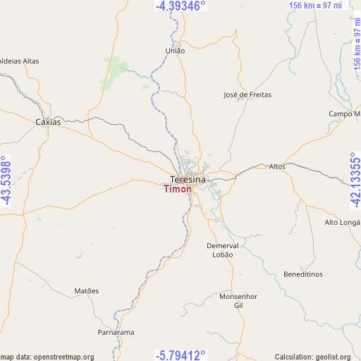
Timon GPS coordinates[2]
5° 5' 39.012" South, 42° 50' 12.012" West
| Map corner | latitude | longitude |
|---|---|---|
| Upper-left | -4.39346°, | -43.5398° |
| Center: | -5.09417°, | -42.83667° |
| Lower-right: | -5.79412°, | -42.13355° |
| Map W x H: | 155.7×155.7 km | = 96.7×96.7mi |
| max Lat: | 2.81972° ⇑11.5% North |
| Timon: | -5.09417° |
| min Lat: | ⇓88.5% South -33.69111° |
| min Long | Timon | max Long |
| -72.89583° | -42.83667° | -32.41083° |
| W 61.5%⇐ | ⇒38.5% E |
Elevation
Elevation of Timon is 76 m = 249 ft, and this is 304.9 m = 1000 ft below average elevation for this country.
| Max E: |
1603 m = 5259 ft | 75% |
| Avg. | 380.9 m = 1250 ft | |
| Timon | 76 m = 249 ft | |
Min E: |
0 m = 0 ft | 25% |
See also: Timon elevation on elevation.city.
Geographical zone
Timon is located in South Torrid zone (between Equator and Tropic of Capricorn). Distance of Equator is 566.4 km =351.9 mi to North.| Distance of | km | miles | from Timon |
|---|---|---|---|
| Equator | 566.4 | 351.9 | to North |
| Tropic Capricorn | 2039.5 | 1267.3 | to South |
| Antarctic Circle | 6834.8 | 4246.9 | to South |
| South Pole | 9440.6 | 5866.1 | to South |


Nearby cities:
15 places around Timon: (largest is in red/bold)
• Alto Longá
71.5 km =44.4 mi,  104°
104°
• Altos
42.2 km =26.2 mi,  81°
81°
• Beneditinos
65.4 km =40.6 mi,  127°
127°
• Campo Maior
79.7 km =49.5 mi,  68°
68°
• Caxias
63.2 km =39.3 mi,  294°
294°
• Coelho Neto
95.1 km =59.1 mi,  348°
348°
• Demerval Lobão
34.3 km =21.3 mi,  148°
148°
• Estreito
89.2 km =55.4 mi,  210°
210°
• José de Freitas
47.4 km =29.5 mi,  37°
37°
• Monsenhor Gil
58.1 km =36.1 mi, 154°
• Parnarama
71.2 km =44.2 mi,  203°
203°
• São Pedro do Piauí
93.8 km =58.3 mi,  171°
171°
• Teresina
3.9 km =2.4 mi, 81°
• União
56.6 km =35.2 mi,  356°
356°
• Água Branca
91.5 km =56.9 mi, 165°
Sources, notices
• [Note1] Compared only with cities in Brazil existing in our database
• [Src1] Map data: © OpenStreetMap contributors (CC-BY-SA)
• [Src2] Other city data from geonames.org with taken over terms of usage.
• [Src3] Geographical zone / Annual Mean Temperature by Robert A. Rohde @ Wikipedia
