Altos geodata
Altos (Piauí) is a populated place; located in Brazil in America/Fortaleza (GMT-3) time zone. With population of 28,768 people, there are 689 cities with bigger population in this country. Compared to other cities in Brazil, 88.7% of cities are located further ↓South; 63.8% of cities are located further ←West and 62.1% of cities have higher elevation than Altos. Note1


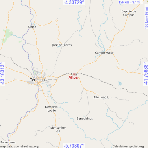
Altos GPS coordinates[2]
5° 2' 17.016" South, 42° 27' 36" West
| Map corner | latitude | longitude |
|---|---|---|
| Upper-left | -4.33729°, | -43.16313° |
| Center: | -5.03806°, | -42.46° |
| Lower-right: | -5.73807°, | -41.75688° |
| Map W x H: | 155.8×155.8 km | = 96.8×96.8mi |
| max Lat: | 2.81972° ⇑11.3% North |
| Altos: | -5.03806° |
| min Lat: | ⇓88.7% South -33.69111° |
| min Long | Altos | max Long |
| -72.89583° | -42.46° | -32.41083° |
| W 63.8%⇐ | ⇒36.2% E |
Elevation
Elevation of Altos is 192 m = 630 ft, and this is 188.9 m = 620 ft below average elevation for this country.
| Max E: |
1603 m = 5259 ft | 62.1% |
| Avg. | 380.9 m = 1250 ft | |
| Altos | 192 m = 630 ft | |
Min E: |
0 m = 0 ft | 37.9% |
See also: Brazil elevation on elevation.city.
Geographical zone
Altos is located in South Torrid zone (between Equator and Tropic of Capricorn). Distance of Equator is 560.2 km =348.1 mi to North.| Distance of | km | miles | from Altos |
|---|---|---|---|
| Equator | 560.2 | 348.1 | to North |
| Tropic Capricorn | 2045.7 | 1271.1 | to South |
| Antarctic Circle | 6841 | 4250.8 | to South |
| South Pole | 9446.9 | 5870 | to South |


Nearby cities:
15 places around Altos: (largest is in red/bold)
• Alto Longá
36.4 km =22.6 mi,  130°
130°
• Barras
90.1 km =56 mi,  11°
11°
• Beneditinos
47 km =29.2 mi,  167°
167°
• Campo Maior
39.9 km =24.8 mi,  54°
54°
• Castelo do Piauí
105.3 km =65.4 mi,  107°
107°
• Caxias
101.2 km =62.9 mi,  281°
281°
• Demerval Lobão
42.9 km =26.7 mi,  213°
213°
• José de Freitas
33.8 km =21 mi,  337°
337°
• Monsenhor Gil
60.7 km =37.7 mi,  195°
195°
• Parnarama
100.2 km =62.3 mi,  224°
224°
• São Pedro do Piauí
103.2 km =64.1 mi, 196°
• Teresina
38.3 km =23.8 mi,  261°
261°
• Timon
42.2 km =26.2 mi, 261°
• União
67.3 km =41.8 mi,  318°
318°
• Água Branca
97 km =60.3 mi,  191°
191°
Sources, notices
• [Note1] Compared only with cities in Brazil existing in our database
• [Src1] Map data: © OpenStreetMap contributors (CC-BY-SA)
• [Src2] Other city data from geonames.org with taken over terms of usage.
• [Src3] Geographical zone / Annual Mean Temperature by Robert A. Rohde @ Wikipedia
