Chavantes geodata
Chavantes (São Paulo) is a populated place; located in Brazil in America/Sao_Paulo (GMT-3) time zone. With population of 10,306 people, there are 1621 cities with bigger population in this country. Compared to other cities in Brazil, 78.9% of cities are located further ↑North; 76.9% of cities are located further →East and 67.5% of cities have lower elevation than Chavantes. Note1


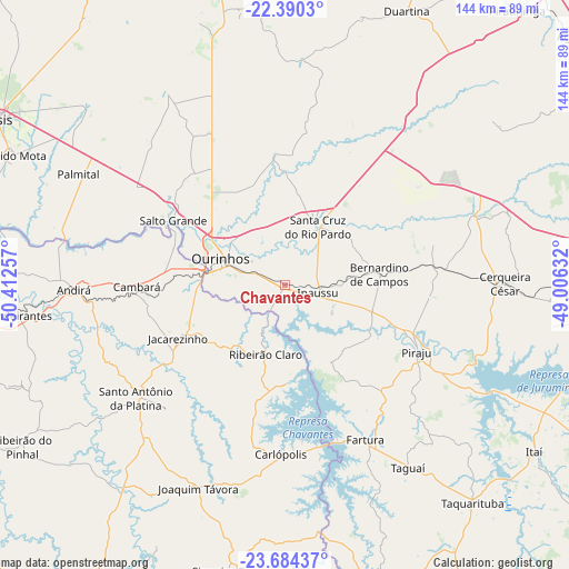
Chavantes GPS coordinates[2]
23° 2' 20.004" South, 49° 42' 33.984" West
| Map corner | latitude | longitude |
|---|---|---|
| Upper-left | -22.3903°, | -50.41257° |
| Center: | -23.03889°, | -49.70944° |
| Lower-right: | -23.68437°, | -49.00632° |
| Map W x H: | 143.9×143.9 km | = 89.4×89.4mi |
| max Lat: | 2.81972° ⇑78.9% North |
| Chavantes: | -23.03889° |
| min Lat: | ⇓21.1% South -33.69111° |
| min Long | Chavantes | max Long |
| -72.89583° | -49.70944° | -32.41083° |
| W 23.1%⇐ | ⇒76.9% E |
Elevation
Elevation of Chavantes is 553 m = 1814 ft, and this is 172.1 m = 565 ft above average elevation for this country.
| Max E: |
1603 m = 5259 ft | 32.5% |
| Chavantes | 553 m 1814 ft | |
| Avg. | 380.9 m = 1250 ft | |
Min E: |
0 m = 0 ft | 67.5% |
See also: Brazil elevation on elevation.city.
Geographical zone
Chavantes is located in South Torrid zone (between Equator and Tropic of Capricorn). Distance of this Southern Tropic circle is 44.2 km =27.5 mi to South.| Distance of | km | miles | from Chavantes |
|---|---|---|---|
| Equator | 2561.7 | 1591.8 | to North |
| Tropic Capricorn | 44.2 | 27.5 | to South |
| Antarctic Circle | 4839.5 | 3007.1 | to South |
| South Pole | 7445.4 | 4626.4 | to South |


Nearby cities:
15 places around Chavantes: (largest is in red/bold)
• Bandeirantes
67.8 km =42.1 mi,  263°
263°
• Bernardino de Campos
24.2 km =15 mi,  83°
83°
• Cambará
37.3 km =23.2 mi,  268°
268°
• Cerqueira César
55.6 km =34.5 mi,  89°
89°
• Fartura
43.9 km =27.3 mi,  152°
152°
• Ipauçu
8.7 km =5.4 mi,  103°
103°
• Itaí
76 km =47.2 mi,  123°
123°
• Jacarezinho
29.8 km =18.5 mi,  243°
243°
• Ourinhos
17.8 km =11.1 mi,  292°
292°
• Palmital
59 km =36.7 mi,  298°
298°
• Piraju
37.5 km =23.3 mi, 117°
• Santa Cruz do Rio Pardo
17.4 km =10.8 mi,  26°
26°
• Santo Antônio da Platina
47.2 km =29.3 mi,  232°
232°
• Siqueira Campos
73.4 km =45.6 mi,  189°
189°
• Taquarituba
72.6 km =45.1 mi,  139°
139°
Sources, notices
• [Note1] Compared only with cities in Brazil existing in our database
• [Src1] Map data: © OpenStreetMap contributors (CC-BY-SA)
• [Src2] Other city data from geonames.org with taken over terms of usage.
• [Src3] Geographical zone / Annual Mean Temperature by Robert A. Rohde @ Wikipedia
