Cerqueira César geodata
Cerqueira César (São Paulo) is a populated place; located in Brazil in America/Sao_Paulo (GMT-3) time zone. With population of 14,260 people, there are 1271 cities with bigger population in this country. Compared to other cities in Brazil, 78.9% of cities are located further ↑North; 72.8% of cities are located further →East and 83.5% of cities have lower elevation than Cerqueira César. Note1


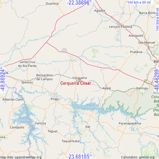
Cerqueira César GPS coordinates[2]
23° 2' 8.016" South, 49° 9' 57.996" West
| Map corner | latitude | longitude |
|---|---|---|
| Upper-left | -22.38696°, | -49.86924° |
| Center: | -23.03556°, | -49.16611° |
| Lower-right: | -23.68105°, | -48.46299° |
| Map W x H: | 143.9×143.9 km | = 89.4×89.4mi |
| max Lat: | 2.81972° ⇑78.9% North |
| Cerqueira César: | -23.03556° |
| min Lat: | ⇓21.1% South -33.69111° |
| min Long | Cerqueira Césa | max Long |
| -72.89583° | -49.16611° | -32.41083° |
| W 27.2%⇐ | ⇒72.8% E |
Elevation
Elevation of Cerqueira César is 740 m = 2428 ft, and this is 359.1 m = 1178 ft above average elevation for this country.
| Max E: |
1603 m = 5259 ft | 16.5% |
| Cerqueira César | 740 m 2428 ft | |
| Avg. | 380.9 m = 1250 ft | |
Min E: |
0 m = 0 ft | 83.5% |
See also: Brazil elevation on elevation.city.
Geographical zone
Cerqueira César is located in South Torrid zone (between Equator and Tropic of Capricorn). Distance of this Southern Tropic circle is 44.6 km =27.7 mi to South.| Distance of | km | miles | from Cerqueira César |
|---|---|---|---|
| Equator | 2561.3 | 1591.5 | to North |
| Tropic Capricorn | 44.6 | 27.7 | to South |
| Antarctic Circle | 4839.9 | 3007.4 | to South |
| South Pole | 7445.7 | 4626.5 | to South |


Nearby cities:
15 places around Cerqueira César: (largest is in red/bold)
• Agudos
65.6 km =40.8 mi,  16°
16°
• Avaré
25.6 km =15.9 mi,  105°
105°
• Bernardino de Campos
31.6 km =19.6 mi,  274°
274°
• Chavantes
55.6 km =34.5 mi, 269°
• Fartura
52.7 km =32.7 mi,  221°
221°
• Ipauçu
47.2 km =29.3 mi, 267°
• Itatinga
56.8 km =35.3 mi,  97°
97°
• Itaí
43.2 km =26.8 mi,  169°
169°
• Lençóis Paulista
61.4 km =38.2 mi,  37°
37°
• Ourinhos
72.4 km =45 mi, 274°
• Paranapanema
59.7 km =37.1 mi,  130°
130°
• Piraju
28.4 km =17.6 mi,  231°
231°
• Santa Cruz do Rio Pardo
50.1 km =31.1 mi,  287°
287°
• São Manuel
69.8 km =43.4 mi,  60°
60°
• Taquarituba
55.9 km =34.7 mi,  188°
188°
Sources, notices
• [Note1] Compared only with cities in Brazil existing in our database
• [Src1] Map data: © OpenStreetMap contributors (CC-BY-SA)
• [Src2] Other city data from geonames.org with taken over terms of usage.
• [Src3] Geographical zone / Annual Mean Temperature by Robert A. Rohde @ Wikipedia
