Itaí geodata
Itaí (São Paulo) is a populated place; located in Brazil in America/Sao_Paulo (GMT-3) time zone. With population of 22,304 people, there are 861 cities with bigger population in this country. Compared to other cities in Brazil, 82% of cities are located further ↑North; 72.2% of cities are located further →East and 74.2% of cities have lower elevation than Itaí. Note1


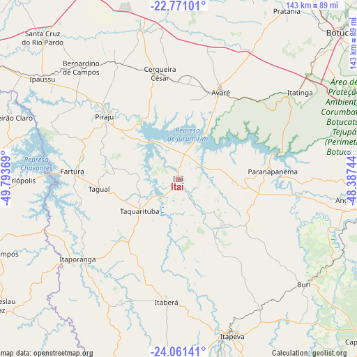
Itaí GPS coordinates[2]
23° 25' 4.008" South, 49° 5' 26.016" West
| Map corner | latitude | longitude |
|---|---|---|
| Upper-left | -22.77101°, | -49.79369° |
| Center: | -23.41778°, | -49.09056° |
| Lower-right: | -24.06141°, | -48.38744° |
| Map W x H: | 143.5×143.5 km | = 89.2×89.2mi |
| max Lat: | 2.81972° ⇑82% North |
| Itaí: | -23.41778° |
| min Lat: | ⇓18% South -33.69111° |
| min Long | Itaí | max Long |
| -72.89583° | -49.09056° | -32.41083° |
| W 27.8%⇐ | ⇒72.2% E |
Elevation
Elevation of Itaí is 616 m = 2021 ft, and this is 235.1 m = 771 ft above average elevation for this country.
| Max E: |
1603 m = 5259 ft | 25.8% |
| Itaí | 616 m 2021 ft | |
| Avg. | 380.9 m = 1250 ft | |
Min E: |
0 m = 0 ft | 74.2% |
See also: Brazil elevation on elevation.city.
Geographical zone
Itaí is located in South Torrid zone (between Equator and Tropic of Capricorn). Distance of this Southern Tropic circle is 2.1 km =1.3 mi to South.| Distance of | km | miles | from Itaí |
|---|---|---|---|
| Equator | 2603.8 | 1617.9 | to North |
| Tropic Capricorn | 2.1 | 1.3 | to South |
| Antarctic Circle | 4797.4 | 2981 | to South |
| South Pole | 7403.2 | 4600.1 | to South |


Nearby cities:
15 places around Itaí: (largest is in red/bold)
• Angatuba
69.6 km =43.2 mi,  96°
96°
• Avaré
39.3 km =24.4 mi,  25°
25°
• Bernardino de Campos
59.7 km =37.1 mi,  318°
318°
• Buri
66 km =41 mi,  129°
129°
• Cerqueira César
43.2 km =26.8 mi,  349°
349°
• Chavantes
76 km =47.2 mi,  303°
303°
• Fartura
42.9 km =26.7 mi,  274°
274°
• Ipauçu
67.9 km =42.2 mi,  306°
306°
• Itaberá
49.6 km =30.8 mi,  185°
185°
• Itapeva
66.5 km =41.3 mi,  160°
160°
• Itaporanga
51.9 km =32.2 mi,  231°
231°
• Itatinga
59.9 km =37.2 mi,  54°
54°
• Paranapanema
37.5 km =23.3 mi,  84°
84°
• Piraju
39 km =24.2 mi, 309°
• Taquarituba
20.3 km =12.6 mi, 230°
Sources, notices
• [Note1] Compared only with cities in Brazil existing in our database
• [Src1] Map data: © OpenStreetMap contributors (CC-BY-SA)
• [Src2] Other city data from geonames.org with taken over terms of usage.
• [Src3] Geographical zone / Annual Mean Temperature by Robert A. Rohde @ Wikipedia
