Ipauçu geodata
Ipauçu (São Paulo) is a populated place; located in Brazil in America/Sao_Paulo (GMT-3) time zone. With population of 10,833 people, there are 1579 cities with bigger population in this country. Compared to other cities in Brazil, 79.2% of cities are located further ↑North; 76.3% of cities are located further →East and 70.3% of cities have lower elevation than Ipauçu. Note1


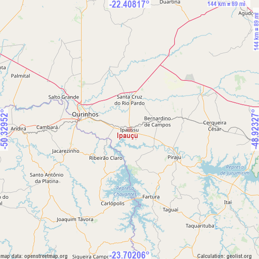
Ipauçu GPS coordinates[2]
23° 3' 24.012" South, 49° 37' 35.004" West
| Map corner | latitude | longitude |
|---|---|---|
| Upper-left | -22.40817°, | -50.32952° |
| Center: | -23.05667°, | -49.62639° |
| Lower-right: | -23.70206°, | -48.92327° |
| Map W x H: | 143.9×143.9 km | = 89.4×89.4mi |
| max Lat: | 2.81972° ⇑79.2% North |
| Ipauçu: | -23.05667° |
| min Lat: | ⇓20.8% South -33.69111° |
| min Long | Ipauçu | max Long |
| -72.89583° | -49.62639° | -32.41083° |
| W 23.7%⇐ | ⇒76.3% E |
Elevation
Elevation of Ipauçu is 575 m = 1886 ft, and this is 194.1 m = 637 ft above average elevation for this country.
| Max E: |
1603 m = 5259 ft | 29.7% |
| Ipauçu | 575 m 1886 ft | |
| Avg. | 380.9 m = 1250 ft | |
Min E: |
0 m = 0 ft | 70.3% |
See also: Brazil elevation on elevation.city.
Geographical zone
Ipauçu is located in South Torrid zone (between Equator and Tropic of Capricorn). Distance of this Southern Tropic circle is 42.3 km =26.3 mi to South.| Distance of | km | miles | from Ipauçu |
|---|---|---|---|
| Equator | 2563.7 | 1593 | to North |
| Tropic Capricorn | 42.3 | 26.3 | to South |
| Antarctic Circle | 4837.5 | 3005.9 | to South |
| South Pole | 7443.4 | 4625.1 | to South |


Nearby cities:
15 places around Ipauçu: (largest is in red/bold)
• Avaré
71.8 km =44.6 mi,  93°
93°
• Bernardino de Campos
16.3 km =10.1 mi,  72°
72°
• Cambará
45.8 km =28.5 mi,  271°
271°
• Cerqueira César
47.2 km =29.3 mi, 87°
• Chavantes
8.7 km =5.4 mi,  283°
283°
• Fartura
38.7 km =24 mi,  162°
162°
• Itaí
67.9 km =42.2 mi,  126°
126°
• Jacarezinho
36.9 km =22.9 mi,  251°
251°
• Ourinhos
26.4 km =16.4 mi,  289°
289°
• Palmital
67.5 km =41.9 mi,  296°
296°
• Piraju
29.1 km =18.1 mi,  121°
121°
• Santa Cruz do Rio Pardo
17.6 km =10.9 mi,  357°
357°
• Santo Antônio da Platina
53.2 km =33.1 mi,  240°
240°
• Siqueira Campos
73.4 km =45.6 mi,  196°
196°
• Taquarituba
65.8 km =40.9 mi,  143°
143°
Sources, notices
• [Note1] Compared only with cities in Brazil existing in our database
• [Src1] Map data: © OpenStreetMap contributors (CC-BY-SA)
• [Src2] Other city data from geonames.org with taken over terms of usage.
• [Src3] Geographical zone / Annual Mean Temperature by Robert A. Rohde @ Wikipedia
