Vera Cruz geodata
Vera Cruz (Bahia) is a populated place; located in Brazil in America/Bahia (GMT-3) time zone. With population of 30,556 people, there are 660 cities with bigger population in this country. Compared to other cities in Brazil, 60.9% of cities are located further ↓South; 69.9% of cities are located further ←West and 66.1% of cities have lower elevation than Vera Cruz. Note1


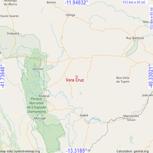
Vera Cruz GPS coordinates[2]
12° 37' 59.988" South, 41° 1' 59.988" West
| Map corner | latitude | longitude |
|---|---|---|
| Upper-left | -11.94632°, | -41.73646° |
| Center: | -12.63333°, | -41.03333° |
| Lower-right: | -13.3185°, | -40.33021° |
| Map W x H: | 152.6×152.6 km | = 94.8×94.8mi |
| max Lat: | 2.81972° ⇑39.1% North |
| Vera Cruz: | -12.63333° |
| min Lat: | ⇓60.9% South -33.69111° |
| min Long | Vera Cruz | max Long |
| -72.89583° | -41.03333° | -32.41083° |
| W 69.9%⇐ | ⇒30.1% E |
Elevation
Elevation of Vera Cruz is 533 m = 1749 ft, and this is 152.1 m = 499 ft above average elevation for this country.
| Max E: |
1603 m = 5259 ft | 33.9% |
| Vera Cruz | 533 m 1749 ft | |
| Avg. | 380.9 m = 1250 ft | |
Min E: |
0 m = 0 ft | 66.1% |
See also: Brazil elevation on elevation.city.
Geographical zone
Vera Cruz is located in South Torrid zone (between Equator and Tropic of Capricorn). Distance of this Southern Tropic circle is 1201.2 km =746.4 mi to South.| Distance of | km | miles | from Vera Cruz |
|---|---|---|---|
| Equator | 1404.7 | 872.8 | to North |
| Tropic Capricorn | 1201.2 | 746.4 | to South |
| Antarctic Circle | 5996.5 | 3726.1 | to South |
| South Pole | 8602.4 | 5345.3 | to South |


Nearby cities:
15 places around Vera Cruz: (largest is in red/bold)
• Baixa Grande
120.2 km =74.7 mi,  51°
51°
• Barra da Estiva
114.9 km =71.4 mi,  196°
196°
• Cafarnaum
114.7 km =71.3 mi,  335°
335°
• Canarana
132.4 km =82.3 mi,  322°
322°
• Iaçu
90.4 km =56.2 mi,  99°
99°
• Iraquara
76.7 km =47.7 mi,  303°
303°
• Itaberaba
79.7 km =49.5 mi,  81°
81°
• Maracás
111 km =69 mi,  143°
143°
• Morro do Chapéu
121.4 km =75.4 mi,  353°
353°
• Mundo Novo
105.5 km =65.6 mi,  35°
35°
• Piritiba
113.1 km =70.3 mi,  27°
27°
• Ruy Barbosa
70.3 km =43.7 mi,  56°
56°
• Seabra
83.5 km =51.9 mi,  286°
286°
• Tapiramutá
91.3 km =56.7 mi,  16°
16°
• Terra Nova
49.6 km =30.8 mi, 53°
Sources, notices
• [Note1] Compared only with cities in Brazil existing in our database
• [Src1] Map data: © OpenStreetMap contributors (CC-BY-SA)
• [Src2] Other city data from geonames.org with taken over terms of usage.
• [Src3] Geographical zone / Annual Mean Temperature by Robert A. Rohde @ Wikipedia
