Iaçu geodata
Iaçu (Bahia) is a populated place; located in Brazil in America/Bahia (GMT-3) time zone. With population of 22,664 people, there are 844 cities with bigger population in this country. Compared to other cities in Brazil, 60.5% of cities are located further ↓South; 74.4% of cities are located further ←West and 57.4% of cities have higher elevation than Iaçu. Note1


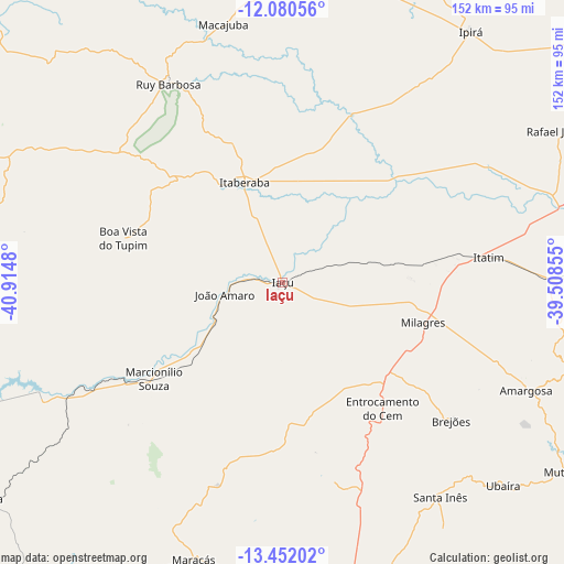
Iaçu GPS coordinates[2]
12° 46' 1.992" South, 40° 12' 42.012" West
| Map corner | latitude | longitude |
|---|---|---|
| Upper-left | -12.08056°, | -40.9148° |
| Center: | -12.76722°, | -40.21167° |
| Lower-right: | -13.45202°, | -39.50855° |
| Map W x H: | 152.5×152.5 km | = 94.8×94.8mi |
| max Lat: | 2.81972° ⇑39.5% North |
| Iaçu: | -12.76722° |
| min Lat: | ⇓60.5% South -33.69111° |
| min Long | Iaçu | max Long |
| -72.89583° | -40.21167° | -32.41083° |
| W 74.4%⇐ | ⇒25.6% E |
Elevation
Elevation of Iaçu is 240 m = 787 ft, and this is 140.9 m = 462 ft below average elevation for this country.
| Max E: |
1603 m = 5259 ft | 57.4% |
| Avg. | 380.9 m = 1250 ft | |
| Iaçu | 240 m = 787 ft | |
Min E: |
0 m = 0 ft | 42.6% |
See also: Brazil elevation on elevation.city.
Geographical zone
Iaçu is located in South Torrid zone (between Equator and Tropic of Capricorn). Distance of this Southern Tropic circle is 1186.3 km =737.1 mi to South.| Distance of | km | miles | from Iaçu |
|---|---|---|---|
| Equator | 1419.6 | 882.1 | to North |
| Tropic Capricorn | 1186.3 | 737.1 | to South |
| Antarctic Circle | 5981.6 | 3716.8 | to South |
| South Pole | 8587.5 | 5336 | to South |


Nearby cities:
15 places around Iaçu: (largest is in red/bold)
• Amargosa
72 km =44.7 mi,  113°
113°
• Baixa Grande
89.9 km =55.9 mi,  3°
3°
• Castro Alves
84.9 km =52.8 mi,  89°
89°
• Ipirá
85.1 km =52.9 mi,  37°
37°
• Itaberaba
28.6 km =17.8 mi,  338°
338°
• Itiruçu
85.3 km =53 mi,  175°
175°
• Jaguaquara
88.8 km =55.2 mi,  162°
162°
• Maracás
78.6 km =48.8 mi,  197°
197°
• Mundo Novo
104.9 km =65.2 mi, 344°
• Mutuípe
92.2 km =57.3 mi,  123°
123°
• Ruy Barbosa
61.9 km =38.5 mi,  330°
330°
• Santa Inês
72.2 km =44.9 mi,  143°
143°
• Terra Nova
66.5 km =41.3 mi,  312°
312°
• Ubaíra
81.5 km =50.6 mi,  133°
133°
• Vera Cruz
90.4 km =56.2 mi,  279°
279°
Sources, notices
• [Note1] Compared only with cities in Brazil existing in our database
• [Src1] Map data: © OpenStreetMap contributors (CC-BY-SA)
• [Src2] Other city data from geonames.org with taken over terms of usage.
• [Src3] Geographical zone / Annual Mean Temperature by Robert A. Rohde @ Wikipedia
