Itaberaba geodata
Itaberaba (Bahia) is a populated place; located in Brazil in America/Bahia (GMT-3) time zone. With population of 47,301 people, there are 457 cities with bigger population in this country. Compared to other cities in Brazil, 61.1% of cities are located further ↓South; 74% of cities are located further ←West and 54.6% of cities have higher elevation than Itaberaba. Note1


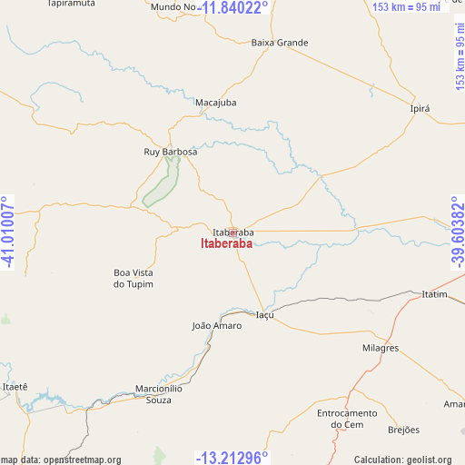
Itaberaba GPS coordinates[2]
12° 31' 39" South, 40° 18' 24.984" West
| Map corner | latitude | longitude |
|---|---|---|
| Upper-left | -11.84022°, | -41.01007° |
| Center: | -12.5275°, | -40.30694° |
| Lower-right: | -13.21296°, | -39.60382° |
| Map W x H: | 152.6×152.6 km | = 94.8×94.8mi |
| max Lat: | 2.81972° ⇑38.9% North |
| Itaberaba: | -12.5275° |
| min Lat: | ⇓61.1% South -33.69111° |
| min Long | Itaberaba | max Long |
| -72.89583° | -40.30694° | -32.41083° |
| W 74%⇐ | ⇒26% E |
Elevation
Elevation of Itaberaba is 274 m = 899 ft, and this is 106.9 m = 351 ft below average elevation for this country.
| Max E: |
1603 m = 5259 ft | 54.6% |
| Avg. | 380.9 m = 1250 ft | |
| Itaberaba | 274 m = 899 ft | |
Min E: |
0 m = 0 ft | 45.4% |
See also: Itaberaba elevation on elevation.city.
Geographical zone
Itaberaba is located in South Torrid zone (between Equator and Tropic of Capricorn). Distance of this Southern Tropic circle is 1213 km =753.7 mi to South.| Distance of | km | miles | from Itaberaba |
|---|---|---|---|
| Equator | 1392.9 | 865.5 | to North |
| Tropic Capricorn | 1213 | 753.7 | to South |
| Antarctic Circle | 6008.2 | 3733.3 | to South |
| South Pole | 8614.1 | 5352.6 | to South |


Nearby cities:
15 places around Itaberaba: (largest is in red/bold)
• Amargosa
94.5 km =58.7 mi,  126°
126°
• Baixa Grande
64.9 km =40.3 mi,  13°
13°
• Castro Alves
98.9 km =61.5 mi,  105°
105°
• Iaçu
28.6 km =17.8 mi,  158°
158°
• Ipirá
74.3 km =46.2 mi,  56°
56°
• Mairi
92.4 km =57.4 mi, 10°
• Maracás
102.5 km =63.7 mi,  187°
187°
• Mundo Novo
76.5 km =47.5 mi,  346°
346°
• Piritiba
92.7 km =57.6 mi,  343°
343°
• Ruy Barbosa
33.9 km =21.1 mi,  323°
323°
• Santa Inês
100.1 km =62.2 mi,  148°
148°
• Tapiramutá
92.2 km =57.3 mi,  325°
325°
• Terra Nova
43 km =26.7 mi,  294°
294°
• Ubaíra
108 km =67.1 mi,  139°
139°
• Vera Cruz
79.7 km =49.5 mi,  261°
261°
Sources, notices
• [Note1] Compared only with cities in Brazil existing in our database
• [Src1] Map data: © OpenStreetMap contributors (CC-BY-SA)
• [Src2] Other city data from geonames.org with taken over terms of usage.
• [Src3] Geographical zone / Annual Mean Temperature by Robert A. Rohde @ Wikipedia
