Ipirá geodata
Ipirá (Bahia) is a populated place; located in Brazil in America/Bahia (GMT-3) time zone. With population of 27,217 people, there are 726 cities with bigger population in this country. Compared to other cities in Brazil, 62.1% of cities are located further ↓South; 76.3% of cities are located further ←West and 51.7% of cities have higher elevation than Ipirá. Note1


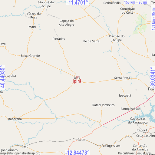
Ipirá GPS coordinates[2]
12° 9' 29.988" South, 39° 44' 13.992" West
| Map corner | latitude | longitude |
|---|---|---|
| Upper-left | -11.4701°, | -40.44035° |
| Center: | -12.15833°, | -39.73722° |
| Lower-right: | -12.84478°, | -39.0341° |
| Map W x H: | 152.9×152.9 km | = 95×95mi |
| max Lat: | 2.81972° ⇑37.9% North |
| Ipirá: | -12.15833° |
| min Lat: | ⇓62.1% South -33.69111° |
| min Long | Ipirá | max Long |
| -72.89583° | -39.73722° | -32.41083° |
| W 76.3%⇐ | ⇒23.7% E |
Elevation
Elevation of Ipirá is 331 m = 1086 ft, and this is 49.9 m = 164 ft below average elevation for this country.
| Max E: |
1603 m = 5259 ft | 51.7% |
| Avg. | 380.9 m = 1250 ft | |
| Ipirá | 331 m = 1086 ft | |
Min E: |
0 m = 0 ft | 48.3% |
See also: Brazil elevation on elevation.city.
Geographical zone
Ipirá is located in South Torrid zone (between Equator and Tropic of Capricorn). Distance of this Southern Tropic circle is 1254 km =779.2 mi to South.| Distance of | km | miles | from Ipirá |
|---|---|---|---|
| Equator | 1351.9 | 840 | to North |
| Tropic Capricorn | 1254 | 779.2 | to South |
| Antarctic Circle | 6049.3 | 3758.9 | to South |
| South Pole | 8655.2 | 5378.1 | to South |


Nearby cities:
15 places around Ipirá: (largest is in red/bold)
• Anguera
53.4 km =33.2 mi,  89°
89°
• Baixa Grande
51.8 km =32.2 mi,  295°
295°
• Castro Alves
75.4 km =46.9 mi,  153°
153°
• Conceição da Feira
89 km =55.3 mi,  115°
115°
• Conceição do Coité
82.5 km =51.3 mi,  36°
36°
• Feira de Santana
84.6 km =52.6 mi,  98°
98°
• Iaçu
85.1 km =52.9 mi,  217°
217°
• Itaberaba
74.3 km =46.2 mi,  236°
236°
• Mairi
66.9 km =41.6 mi,  317°
317°
• Mundo Novo
86.6 km =53.8 mi,  292°
292°
• Riachão do Jacuípe
54.7 km =34 mi, 44°
• Ruy Barbosa
83.4 km =51.8 mi,  260°
260°
• Santo Estêvão
60.8 km =37.8 mi, 119°
• São Gonçalo dos Campos
89.1 km =55.4 mi,  110°
110°
• Valente
88.2 km =54.8 mi,  19°
19°
Sources, notices
• [Note1] Compared only with cities in Brazil existing in our database
• [Src1] Map data: © OpenStreetMap contributors (CC-BY-SA)
• [Src2] Other city data from geonames.org with taken over terms of usage.
• [Src3] Geographical zone / Annual Mean Temperature by Robert A. Rohde @ Wikipedia
