Iporã geodata
Iporã (Paraná) is a populated place; located in Brazil in America/Sao_Paulo (GMT-3) time zone. With population of 10,353 people, there are 1617 cities with bigger population in this country. Compared to other cities in Brazil, 86% of cities are located further ↑North; 91.9% of cities are located further →East and 51.8% of cities have lower elevation than Iporã. Note1


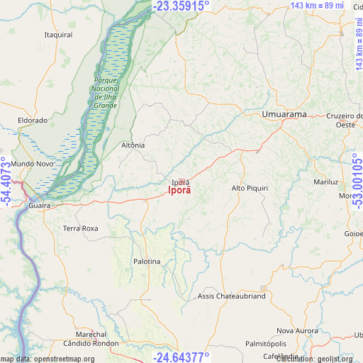
Iporã GPS coordinates[2]
24° 0' 11.016" South, 53° 42' 15.012" West
| Map corner | latitude | longitude |
|---|---|---|
| Upper-left | -23.35915°, | -54.4073° |
| Center: | -24.00306°, | -53.70417° |
| Lower-right: | -24.64377°, | -53.00105° |
| Map W x H: | 142.8×142.8 km | = 88.7×88.7mi |
| max Lat: | 2.81972° ⇑86% North |
| Iporã: | -24.00306° |
| min Lat: | ⇓14% South -33.69111° |
| min Long | Iporã | max Long |
| -72.89583° | -53.70417° | -32.41083° |
| W 8.1%⇐ | ⇒91.9% E |
Elevation
Elevation of Iporã is 377 m = 1237 ft, and this is 3.9 m = 13 ft below average elevation for this country.
| Max E: |
1603 m = 5259 ft | 48.2% |
| Avg. | 380.9 m = 1250 ft | |
| Iporã | 377 m = 1237 ft | |
Min E: |
0 m = 0 ft | 51.8% |
See also: Brazil elevation on elevation.city.
Geographical zone
Iporã is located in South temperate zone (between Tropic of Capricorn and the Antarctic Circle). Distance of this Southern Tropic circle is 63 km =39.1 mi to North.| Distance of | km | miles | from Iporã |
|---|---|---|---|
| Equator | 2668.9 | 1658.4 | to North |
| Tropic Capricorn | 63 | 39.1 | to North |
| Antarctic Circle | 4732.3 | 2940.5 | to South |
| South Pole | 7338.2 | 4559.7 | to South |


Nearby cities:
15 places around Iporã: (largest is in red/bold)
• Alto Piquiri
26.9 km =16.7 mi,  95°
95°
• Altãnia
24.6 km =15.3 mi,  305°
305°
• Cascavel
108.9 km =67.7 mi,  166°
166°
• Corbélia
97.2 km =60.4 mi,  155°
155°
• Cruzeiro do Oeste
68.6 km =42.6 mi,  69°
69°
• Eldorado
63.6 km =39.5 mi,  292°
292°
• Iguatemi
94.3 km =58.6 mi, 292°
• Marechal Cândido Rondon
71.1 km =44.2 mi,  210°
210°
• Moreira Sales
71.1 km =44.2 mi, 95°
• Naviraí
115.5 km =71.8 mi,  334°
334°
• Palotina
34.1 km =21.2 mi,  203°
203°
• Pôrto Barra do Ivinheima
115.3 km =71.6 mi,  1°
1°
• Tapejara
89.7 km =55.7 mi, 70°
• Toledo
79.1 km =49.2 mi,  182°
182°
• Umuarama
46.7 km =29 mi,  55°
55°
Sources, notices
• [Note1] Compared only with cities in Brazil existing in our database
• [Src1] Map data: © OpenStreetMap contributors (CC-BY-SA)
• [Src2] Other city data from geonames.org with taken over terms of usage.
• [Src3] Geographical zone / Annual Mean Temperature by Robert A. Rohde @ Wikipedia
