Serro geodata
Serro (Minas Gerais) is a populated place; located in Brazil in America/Sao_Paulo (GMT-3) time zone. With population of 12,616 people, there are 1408 cities with bigger population in this country. Compared to other cities in Brazil, 52.2% of cities are located further ↑North; 58.6% of cities are located further ←West and 90.5% of cities have lower elevation than Serro. Note1


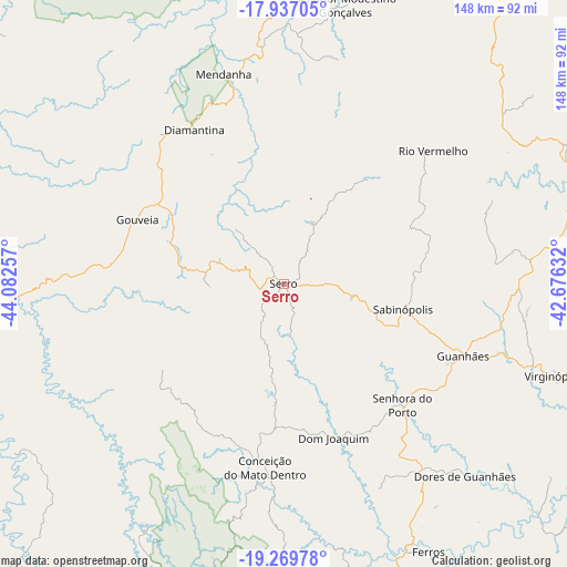
Serro GPS coordinates[2]
18° 36' 16.992" South, 43° 22' 45.984" West
| Map corner | latitude | longitude |
|---|---|---|
| Upper-left | -17.93705°, | -44.08257° |
| Center: | -18.60472°, | -43.37944° |
| Lower-right: | -19.26978°, | -42.67632° |
| Map W x H: | 148.2×148.2 km | = 92.1×92.1mi |
| max Lat: | 2.81972° ⇑52.2% North |
| Serro: | -18.60472° |
| min Lat: | ⇓47.8% South -33.69111° |
| min Long | Serro | max Long |
| -72.89583° | -43.37944° | -32.41083° |
| W 58.6%⇐ | ⇒41.4% E |
Elevation
Elevation of Serro is 821 m = 2694 ft, and this is 440.1 m = 1444 ft above average elevation for this country.
| Max E: |
1603 m = 5259 ft | 9.5% |
| Serro | 821 m 2694 ft | |
| Avg. | 380.9 m = 1250 ft | |
Min E: |
0 m = 0 ft | 90.5% |
See also: Brazil elevation on elevation.city.
Geographical zone
Serro is located in South Torrid zone (between Equator and Tropic of Capricorn). Distance of this Southern Tropic circle is 537.3 km =333.9 mi to South.| Distance of | km | miles | from Serro |
|---|---|---|---|
| Equator | 2068.7 | 1285.4 | to North |
| Tropic Capricorn | 537.3 | 333.9 | to South |
| Antarctic Circle | 5332.5 | 3313.5 | to South |
| South Pole | 7938.4 | 4932.7 | to South |


Nearby cities:
15 places around Serro: (largest is in red/bold)
• Açucena
102 km =63.4 mi,  120°
120°
• Belo Oriente
116.4 km =72.3 mi,  125°
125°
• Conceição do Mato Dentro
48.3 km =30 mi,  185°
185°
• Corinto
116.3 km =72.3 mi,  282°
282°
• Curvelo
112 km =69.6 mi,  261°
261°
• Diamantina
46.3 km =28.8 mi,  329°
329°
• Guanhães
50.7 km =31.5 mi,  111°
111°
• Itabira
113.9 km =70.8 mi,  171°
171°
• Itamarandiba
99.6 km =61.9 mi,  33°
33°
• Lagoa Santa
126.5 km =78.6 mi,  205°
205°
• Peçanha
86.9 km =54 mi,  85°
85°
• Sabinópolis
31.9 km =19.8 mi,  102°
102°
• Santa Maria do Suaçuí
111.8 km =69.5 mi,  65°
65°
• Santana do Paraíso
119.9 km =74.5 mi, 134°
• São João Evangelista
65.2 km =40.5 mi,  84°
84°
Sources, notices
• [Note1] Compared only with cities in Brazil existing in our database
• [Src1] Map data: © OpenStreetMap contributors (CC-BY-SA)
• [Src2] Other city data from geonames.org with taken over terms of usage.
• [Src3] Geographical zone / Annual Mean Temperature by Robert A. Rohde @ Wikipedia
