Belo Oriente geodata
Belo Oriente (Minas Gerais) is a populated place; located in Brazil in America/Sao_Paulo (GMT-3) time zone. With population of 18,470 people, there are 1011 cities with bigger population in this country. Compared to other cities in Brazil, 53.7% of cities are located further ↑North; 63.7% of cities are located further ←West and 55.6% of cities have higher elevation than Belo Oriente. Note1


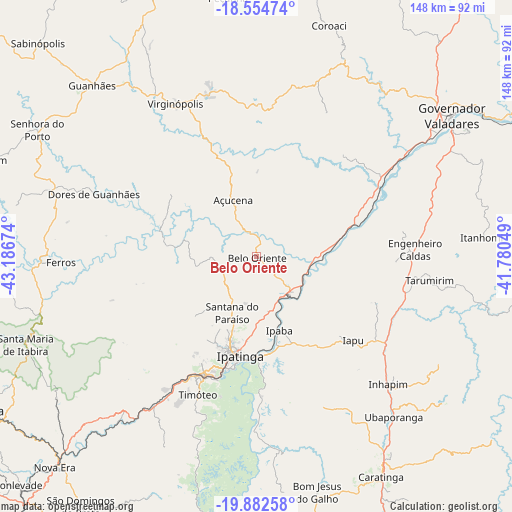
Belo Oriente GPS coordinates[2]
19° 13' 12" South, 42° 29' 0.996" West
| Map corner | latitude | longitude |
|---|---|---|
| Upper-left | -18.55474°, | -43.18674° |
| Center: | -19.22°, | -42.48361° |
| Lower-right: | -19.88258°, | -41.78049° |
| Map W x H: | 147.6×147.6 km | = 91.7×91.7mi |
| max Lat: | 2.81972° ⇑53.7% North |
| Belo Oriente: | -19.22° |
| min Lat: | ⇓46.3% South -33.69111° |
| min Long | Belo Oriente | max Long |
| -72.89583° | -42.48361° | -32.41083° |
| W 63.7%⇐ | ⇒36.3% E |
Elevation
Elevation of Belo Oriente is 261 m = 856 ft, and this is 119.9 m = 393 ft below average elevation for this country.
| Max E: |
1603 m = 5259 ft | 55.6% |
| Avg. | 380.9 m = 1250 ft | |
| Belo Oriente | 261 m = 856 ft | |
Min E: |
0 m = 0 ft | 44.4% |
See also: Brazil elevation on elevation.city.
Geographical zone
Belo Oriente is located in South Torrid zone (between Equator and Tropic of Capricorn). Distance of this Southern Tropic circle is 468.9 km =291.4 mi to South.| Distance of | km | miles | from Belo Oriente |
|---|---|---|---|
| Equator | 2137.1 | 1327.9 | to North |
| Tropic Capricorn | 468.9 | 291.4 | to South |
| Antarctic Circle | 5264.1 | 3271 | to South |
| South Pole | 7870 | 4890.2 | to South |


Nearby cities:
15 places around Belo Oriente: (largest is in red/bold)
• Açucena
17.6 km =10.9 mi,  338°
338°
• Bom Jesus do Galho
69.9 km =43.4 mi,  165°
165°
• Caratinga
72.9 km =45.3 mi,  150°
150°
• Coronel Fabriciano
36.5 km =22.7 mi,  204°
204°
• Governador Valadares
69.5 km =43.2 mi,  53°
53°
• Guanhães
68.4 km =42.5 mi,  316°
316°
• Inhapim
52.9 km =32.9 mi,  133°
133°
• Ipaba
22.6 km =14 mi,  162°
162°
• Ipatinga
28.2 km =17.5 mi,  191°
191°
• Nova Era
82.7 km =51.4 mi,  224°
224°
• Peçanha
75 km =46.6 mi,  354°
354°
• Santana do Paraíso
18.3 km =11.4 mi,  209°
209°
• São Domingos do Prata
87.9 km =54.6 mi, 215°
• São João Evangelista
80.3 km =49.9 mi, 338°
• Timóteo
43.8 km =27.2 mi, 203°
Sources, notices
• [Note1] Compared only with cities in Brazil existing in our database
• [Src1] Map data: © OpenStreetMap contributors (CC-BY-SA)
• [Src2] Other city data from geonames.org with taken over terms of usage.
• [Src3] Geographical zone / Annual Mean Temperature by Robert A. Rohde @ Wikipedia
