São João Evangelista geodata
São João Evangelista (Minas Gerais) is a populated place; located in Brazil in America/Sao_Paulo (GMT-3) time zone. With population of 10,049 people, there are 1647 cities with bigger population in this country. Compared to other cities in Brazil, 51.9% of cities are located further ↑North; 61.8% of cities are located further ←West and 81.3% of cities have lower elevation than São João Evangelista. Note1


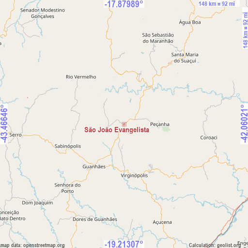
São João Evangelista GPS coordinates[2]
18° 32' 52.008" South, 42° 45' 47.988" West
| Map corner | latitude | longitude |
|---|---|---|
| Upper-left | -17.87989°, | -43.46646° |
| Center: | -18.54778°, | -42.76333° |
| Lower-right: | -19.21307°, | -42.06021° |
| Map W x H: | 148.2×148.2 km | = 92.1×92.1mi |
| max Lat: | 2.81972° ⇑51.9% North |
| São João Evangelista: | -18.54778° |
| min Lat: | ⇓48.1% South -33.69111° |
| min Long | São João Evan | max Long |
| -72.89583° | -42.76333° | -32.41083° |
| W 61.8%⇐ | ⇒38.2% E |
Elevation
Elevation of São João Evangelista is 708 m = 2323 ft, and this is 327.1 m = 1073 ft above average elevation for this country.
| Max E: |
1603 m = 5259 ft | 18.7% |
| São João Evangelista | 708 m 2323 ft | |
| Avg. | 380.9 m = 1250 ft | |
Min E: |
0 m = 0 ft | 81.3% |
See also: Brazil elevation on elevation.city.
Geographical zone
São João Evangelista is located in South Torrid zone (between Equator and Tropic of Capricorn). Distance of this Southern Tropic circle is 543.6 km =337.8 mi to South.| Distance of | km | miles | from São João Evangelista |
|---|---|---|---|
| Equator | 2062.3 | 1281.5 | to North |
| Tropic Capricorn | 543.6 | 337.8 | to South |
| Antarctic Circle | 5338.9 | 3317.4 | to South |
| South Pole | 7944.7 | 4936.6 | to South |


Nearby cities:
15 places around São João Evangelista: (largest is in red/bold)
• Açucena
62.7 km =39 mi,  158°
158°
• Belo Oriente
80.3 km =49.9 mi, 158°
• Capelinha
98.7 km =61.3 mi,  15°
15°
• Conceição do Mato Dentro
88.4 km =54.9 mi,  231°
231°
• Diamantina
94.7 km =58.8 mi,  290°
290°
• Governador Valadares
92.1 km =57.2 mi,  111°
111°
• Guanhães
30.9 km =19.2 mi,  215°
215°
• Ipaba
102.8 km =63.9 mi, 159°
• Ipatinga
105.1 km =65.3 mi,  166°
166°
• Itamarandiba
77.4 km =48.1 mi,  352°
352°
• Peçanha
21.8 km =13.5 mi,  90°
90°
• Sabinópolis
36.3 km =22.6 mi,  248°
248°
• Santa Maria do Suaçuí
54.2 km =33.7 mi,  42°
42°
• Santana do Paraíso
93 km =57.8 mi, 167°
• Serro
65.2 km =40.5 mi,  264°
264°
Sources, notices
• [Note1] Compared only with cities in Brazil existing in our database
• [Src1] Map data: © OpenStreetMap contributors (CC-BY-SA)
• [Src2] Other city data from geonames.org with taken over terms of usage.
• [Src3] Geographical zone / Annual Mean Temperature by Robert A. Rohde @ Wikipedia
