Açucena geodata
Açucena (Minas Gerais) is a populated place; located in Brazil in America/Sao_Paulo (GMT-3) time zone. With population of 14,505 people, there are 1250 cities with bigger population in this country. Compared to other cities in Brazil, 53.5% of cities are located further ↑North; 63.4% of cities are located further ←West and 60.6% of cities have lower elevation than Açucena. Note1


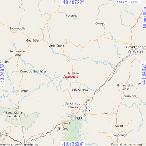
Açucena GPS coordinates[2]
19° 4' 23.016" South, 42° 32' 47.004" West
| Map corner | latitude | longitude |
|---|---|---|
| Upper-left | -18.40722°, | -43.24952° |
| Center: | -19.07306°, | -42.54639° |
| Lower-right: | -19.73624°, | -41.84327° |
| Map W x H: | 147.8×147.8 km | = 91.8×91.8mi |
| max Lat: | 2.81972° ⇑53.5% North |
| Açucena: | -19.07306° |
| min Lat: | ⇓46.5% South -33.69111° |
| min Long | Açucena | max Long |
| -72.89583° | -42.54639° | -32.41083° |
| W 63.4%⇐ | ⇒36.6% E |
Elevation
Elevation of Açucena is 480 m = 1575 ft, and this is 99.1 m = 325 ft above average elevation for this country.
| Max E: |
1603 m = 5259 ft | 39.4% |
| Açucena | 480 m 1575 ft | |
| Avg. | 380.9 m = 1250 ft | |
Min E: |
0 m = 0 ft | 60.6% |
See also: Brazil elevation on elevation.city.
Geographical zone
Açucena is located in South Torrid zone (between Equator and Tropic of Capricorn). Distance of this Southern Tropic circle is 485.2 km =301.5 mi to South.| Distance of | km | miles | from Açucena |
|---|---|---|---|
| Equator | 2120.7 | 1317.7 | to North |
| Tropic Capricorn | 485.2 | 301.5 | to South |
| Antarctic Circle | 5280.4 | 3281.1 | to South |
| South Pole | 7886.3 | 4900.3 | to South |


Nearby cities:
15 places around Açucena: (largest is in red/bold)
• Belo Oriente
17.6 km =10.9 mi,  158°
158°
• Bom Jesus do Galho
87.4 km =54.3 mi, 163°
• Caratinga
90.4 km =56.2 mi,  151°
151°
• Coronel Fabriciano
50.3 km =31.3 mi,  189°
189°
• Governador Valadares
67.4 km =41.9 mi,  68°
68°
• Guanhães
52.4 km =32.6 mi,  309°
309°
• Inhapim
69.3 km =43.1 mi,  139°
139°
• Ipaba
40.1 km =24.9 mi, 160°
• Ipatinga
44 km =27.3 mi,  178°
178°
• Nova Era
91.2 km =56.7 mi,  214°
214°
• Peçanha
58.3 km =36.2 mi,  358°
358°
• Sabinópolis
72.4 km =45 mi, 308°
• Santana do Paraíso
32.4 km =20.1 mi, 184°
• São João Evangelista
62.7 km =39 mi,  338°
338°
• Timóteo
57.5 km =35.7 mi, 190°
Sources, notices
• [Note1] Compared only with cities in Brazil existing in our database
• [Src1] Map data: © OpenStreetMap contributors (CC-BY-SA)
• [Src2] Other city data from geonames.org with taken over terms of usage.
• [Src3] Geographical zone / Annual Mean Temperature by Robert A. Rohde @ Wikipedia
