Itaberá geodata
Itaberá (São Paulo) is a populated place; located in Brazil in America/Sao_Paulo (GMT-3) time zone. With population of 11,097 people, there are 1560 cities with bigger population in this country. Compared to other cities in Brazil, 85.5% of cities are located further ↑North; 72.5% of cities are located further →East and 74.9% of cities have lower elevation than Itaberá. Note1


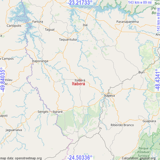
Itaberá GPS coordinates[2]
23° 51' 42.984" South, 49° 8' 13.992" West
| Map corner | latitude | longitude |
|---|---|---|
| Upper-left | -23.21733°, | -49.84035° |
| Center: | -23.86194°, | -49.13722° |
| Lower-right: | -24.50336°, | -48.4341° |
| Map W x H: | 143×143 km | = 88.9×88.9mi |
| max Lat: | 2.81972° ⇑85.5% North |
| Itaberá: | -23.86194° |
| min Lat: | ⇓14.5% South -33.69111° |
| min Long | Itaberá | max Long |
| -72.89583° | -49.13722° | -32.41083° |
| W 27.5%⇐ | ⇒72.5% E |
Elevation
Elevation of Itaberá is 625 m = 2051 ft, and this is 244.1 m = 801 ft above average elevation for this country.
| Max E: |
1603 m = 5259 ft | 25.1% |
| Itaberá | 625 m 2051 ft | |
| Avg. | 380.9 m = 1250 ft | |
Min E: |
0 m = 0 ft | 74.9% |
See also: Brazil elevation on elevation.city.
Geographical zone
Itaberá is located in South temperate zone (between Tropic of Capricorn and the Antarctic Circle). Distance of this Southern Tropic circle is 47.3 km =29.4 mi to North.| Distance of | km | miles | from Itaberá |
|---|---|---|---|
| Equator | 2653.2 | 1648.6 | to North |
| Tropic Capricorn | 47.3 | 29.4 | to North |
| Antarctic Circle | 4748 | 2950.3 | to South |
| South Pole | 7353.9 | 4569.5 | to South |


Nearby cities:
15 places around Itaberá: (largest is in red/bold)
• Apiaí
78 km =48.5 mi,  157°
157°
• Buri
55.8 km =34.7 mi,  82°
82°
• Fartura
64.9 km =40.3 mi,  324°
324°
• Itapeva
29.8 km =18.5 mi,  116°
116°
• Itaporanga
39.8 km =24.7 mi,  295°
295°
• Itararé
34.2 km =21.3 mi,  215°
215°
• Itaí
49.6 km =30.8 mi,  5°
5°
• Jaguariaíva
72 km =44.7 mi,  233°
233°
• Paranapanema
67.6 km =42 mi,  38°
38°
• Piraju
78.5 km =48.8 mi,  341°
341°
• Ribeirão Branco
54.9 km =34.1 mi,  136°
136°
• Sengés
43.3 km =26.9 mi, 229°
• Siqueira Campos
73.5 km =45.7 mi,  285°
285°
• Taquarituba
38.2 km =23.7 mi, 343°
• Wenceslau Braz
67.7 km =42.1 mi,  268°
268°
Sources, notices
• [Note1] Compared only with cities in Brazil existing in our database
• [Src1] Map data: © OpenStreetMap contributors (CC-BY-SA)
• [Src2] Other city data from geonames.org with taken over terms of usage.
• [Src3] Geographical zone / Annual Mean Temperature by Robert A. Rohde @ Wikipedia
