São Manuel geodata
São Manuel (São Paulo) is a populated place; located in Brazil in America/Sao_Paulo (GMT-3) time zone. With population of 33,587 people, there are 614 cities with bigger population in this country. Compared to other cities in Brazil, 75.7% of cities are located further ↑North; 68.4% of cities are located further →East and 81% of cities have lower elevation than São Manuel. Note1


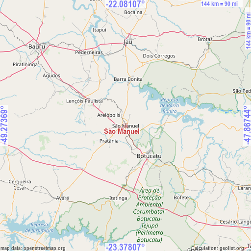
São Manuel GPS coordinates[2]
22° 43' 51.996" South, 48° 34' 14.016" West
| Map corner | latitude | longitude |
|---|---|---|
| Upper-left | -22.08107°, | -49.27369° |
| Center: | -22.73111°, | -48.57056° |
| Lower-right: | -23.37807°, | -47.86744° |
| Map W x H: | 144.2×144.2 km | = 89.6×89.6mi |
| max Lat: | 2.81972° ⇑75.7% North |
| São Manuel: | -22.73111° |
| min Lat: | ⇓24.3% South -33.69111° |
| min Long | São Manuel | max Long |
| -72.89583° | -48.57056° | -32.41083° |
| W 31.6%⇐ | ⇒68.4% E |
Elevation
Elevation of São Manuel is 704 m = 2310 ft, and this is 323.1 m = 1060 ft above average elevation for this country.
| Max E: |
1603 m = 5259 ft | 19% |
| São Manuel | 704 m 2310 ft | |
| Avg. | 380.9 m = 1250 ft | |
Min E: |
0 m = 0 ft | 81% |
See also: Brazil elevation on elevation.city.
Geographical zone
São Manuel is located in South Torrid zone (between Equator and Tropic of Capricorn). Distance of this Southern Tropic circle is 78.5 km =48.8 mi to South.| Distance of | km | miles | from São Manuel |
|---|---|---|---|
| Equator | 2527.5 | 1570.5 | to North |
| Tropic Capricorn | 78.5 | 48.8 | to South |
| Antarctic Circle | 4873.7 | 3028.4 | to South |
| South Pole | 7479.6 | 4647.6 | to South |


Nearby cities:
15 places around São Manuel: (largest is in red/bold)
• Agudos
51.8 km =32.2 mi,  304°
304°
• Avaré
54.7 km =34 mi,  221°
221°
• Barra Bonita
26.3 km =16.3 mi,  2°
2°
• Boracéia
63.5 km =39.5 mi,  340°
340°
• Botucatu
21.5 km =13.4 mi,  143°
143°
• Conchas
65.5 km =40.7 mi,  118°
118°
• Dois Córregos
45 km =28 mi,  25°
25°
• Igaraçu do Tietê
24.7 km =15.3 mi, 3°
• Itapuí
57.4 km =35.7 mi, 344°
• Itatinga
41.5 km =25.8 mi,  186°
186°
• Jaú
48.4 km =30.1 mi, 1°
• Lençóis Paulista
27.8 km =17.3 mi, 302°
• Macatuba
29.3 km =18.2 mi,  330°
330°
• Pederneiras
47.1 km =29.3 mi, 333°
• Porangaba
67.3 km =41.8 mi, 137°
Sources, notices
• [Note1] Compared only with cities in Brazil existing in our database
• [Src1] Map data: © OpenStreetMap contributors (CC-BY-SA)
• [Src2] Other city data from geonames.org with taken over terms of usage.
• [Src3] Geographical zone / Annual Mean Temperature by Robert A. Rohde @ Wikipedia
