Botucatu geodata
Botucatu (São Paulo) is a seat of a second-order administrative division; located in Brazil in America/Sao_Paulo (GMT-3) time zone. With population of 113,862 people, there are 197 cities with bigger population in this country. Compared to other cities in Brazil, 77.6% of cities are located further ↑North; 66.7% of cities are located further →East and 91.5% of cities have lower elevation than Botucatu. Note1


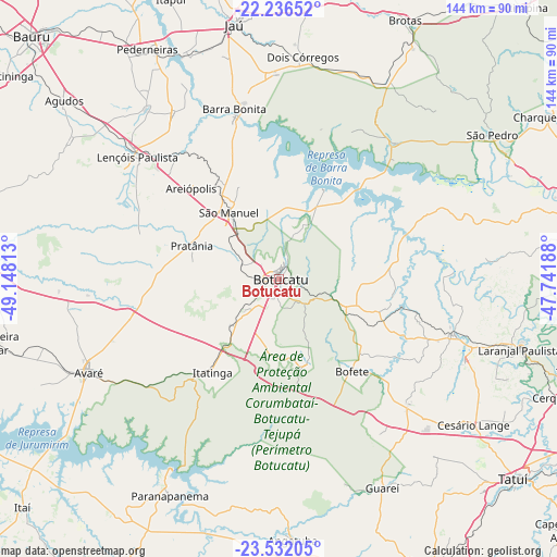
Botucatu GPS coordinates[2]
22° 53' 8.988" South, 48° 26' 42" West
| Map corner | latitude | longitude |
|---|---|---|
| Upper-left | -22.23652°, | -49.14813° |
| Center: | -22.88583°, | -48.445° |
| Lower-right: | -23.53205°, | -47.74188° |
| Map W x H: | 144×144.1 km | = 89.5×89.5mi |
| max Lat: | 2.81972° ⇑77.6% North |
| Botucatu: | -22.88583° |
| min Lat: | ⇓22.4% South -33.69111° |
| min Long | Botucatu | max Long |
| -72.89583° | -48.445° | -32.41083° |
| W 33.3%⇐ | ⇒66.7% E |
Elevation
Elevation of Botucatu is 837 m = 2746 ft, and this is 456.1 m = 1496 ft above average elevation for this country.
| Max E: |
1603 m = 5259 ft | 8.5% |
| Botucatu | 837 m 2746 ft | |
| Avg. | 380.9 m = 1250 ft | |
Min E: |
0 m = 0 ft | 91.5% |
See also: Botucatu elevation on elevation.city.
Geographical zone
Botucatu is located in South Torrid zone (between Equator and Tropic of Capricorn). Distance of this Southern Tropic circle is 61.3 km =38.1 mi to South.| Distance of | km | miles | from Botucatu |
|---|---|---|---|
| Equator | 2544.7 | 1581.2 | to North |
| Tropic Capricorn | 61.3 | 38.1 | to South |
| Antarctic Circle | 4856.5 | 3017.7 | to South |
| South Pole | 7462.4 | 4636.9 | to South |


Nearby cities:
15 places around Botucatu: (largest is in red/bold)
• Angatuba
67.2 km =41.8 mi,  177°
177°
• Avaré
54.6 km =33.9 mi,  244°
244°
• Barra Bonita
45 km =28 mi,  345°
345°
• Conchas
46.8 km =29.1 mi,  107°
107°
• Dois Córregos
58.2 km =36.2 mi,  6°
6°
• Igaraçu do Tietê
43.4 km =27 mi,  344°
344°
• Itatinga
29.7 km =18.5 mi,  216°
216°
• Jaú
66.6 km =41.4 mi, 349°
• Laranjal Paulista
64.9 km =40.3 mi, 106°
• Lençóis Paulista
48.4 km =30.1 mi,  311°
311°
• Macatuba
50.7 km =31.5 mi,  327°
327°
• Paranapanema
62.6 km =38.9 mi,  207°
207°
• Porangaba
46 km =28.6 mi,  134°
134°
• São Manuel
21.5 km =13.4 mi,  323°
323°
• São Pedro
66.1 km =41.1 mi,  55°
55°
Sources, notices
• [Note1] Compared only with cities in Brazil existing in our database
• [Src1] Map data: © OpenStreetMap contributors (CC-BY-SA)
• [Src2] Other city data from geonames.org with taken over terms of usage.
• [Src3] Geographical zone / Annual Mean Temperature by Robert A. Rohde @ Wikipedia
