Avaré geodata
Avaré (São Paulo) is a populated place; located in Brazil in America/Sao_Paulo (GMT-3) time zone. With population of 81,285 people, there are 283 cities with bigger population in this country. Compared to other cities in Brazil, 79.5% of cities are located further ↑North; 71% of cities are located further →East and 86.1% of cities have lower elevation than Avaré. Note1


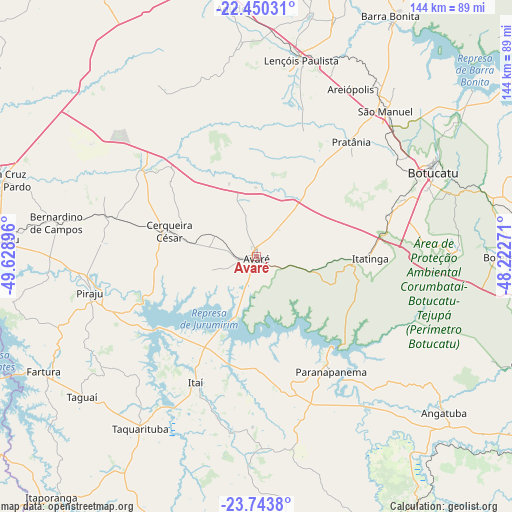
Avaré GPS coordinates[2]
23° 5' 54.996" South, 48° 55' 32.988" West
| Map corner | latitude | longitude |
|---|---|---|
| Upper-left | -22.45031°, | -49.62896° |
| Center: | -23.09861°, | -48.92583° |
| Lower-right: | -23.7438°, | -48.22271° |
| Map W x H: | 143.8×143.8 km | = 89.4×89.4mi |
| max Lat: | 2.81972° ⇑79.5% North |
| Avaré: | -23.09861° |
| min Lat: | ⇓20.5% South -33.69111° |
| min Long | Avaré | max Long |
| -72.89583° | -48.92583° | -32.41083° |
| W 29%⇐ | ⇒71% E |
Elevation
Elevation of Avaré is 768 m = 2520 ft, and this is 387.1 m = 1270 ft above average elevation for this country.
| Max E: |
1603 m = 5259 ft | 13.9% |
| Avaré | 768 m 2520 ft | |
| Avg. | 380.9 m = 1250 ft | |
Min E: |
0 m = 0 ft | 86.1% |
See also: Avaré elevation on elevation.city.
Geographical zone
Avaré is located in South Torrid zone (between Equator and Tropic of Capricorn). Distance of this Southern Tropic circle is 37.6 km =23.4 mi to South.| Distance of | km | miles | from Avaré |
|---|---|---|---|
| Equator | 2568.3 | 1595.9 | to North |
| Tropic Capricorn | 37.6 | 23.4 | to South |
| Antarctic Circle | 4832.8 | 3003 | to South |
| South Pole | 7438.7 | 4622.2 | to South |


Nearby cities:
15 places around Avaré: (largest is in red/bold)
• Agudos
70.3 km =43.7 mi,  354°
354°
• Angatuba
68.1 km =42.3 mi,  129°
129°
• Bernardino de Campos
56.9 km =35.4 mi,  279°
279°
• Botucatu
54.6 km =33.9 mi,  64°
64°
• Cerqueira César
25.6 km =15.9 mi,  285°
285°
• Fartura
67.8 km =42.1 mi,  241°
241°
• Ipauçu
71.8 km =44.6 mi,  273°
273°
• Itatinga
31.7 km =19.7 mi,  90°
90°
• Itaí
39.3 km =24.4 mi,  205°
205°
• Lençóis Paulista
57.1 km =35.5 mi,  13°
13°
• Macatuba
69.9 km =43.4 mi,  18°
18°
• Paranapanema
38 km =23.6 mi,  147°
147°
• Piraju
48 km =29.8 mi,  257°
257°
• São Manuel
54.7 km =34 mi,  41°
41°
• Taquarituba
58.2 km =36.2 mi, 213°
Sources, notices
• [Note1] Compared only with cities in Brazil existing in our database
• [Src1] Map data: © OpenStreetMap contributors (CC-BY-SA)
• [Src2] Other city data from geonames.org with taken over terms of usage.
• [Src3] Geographical zone / Annual Mean Temperature by Robert A. Rohde @ Wikipedia
