Porangaba geodata
Porangaba (São Paulo) is a seat of a second-order administrative division; located in Brazil in America/Sao_Paulo (GMT-3) time zone. In our database, there are 2019 cities with bigger population. Compared to other cities in Brazil, 80.1% of cities are located further ↑North; 65.1% of cities are located further →East and 67% of cities have lower elevation than Porangaba. Note1


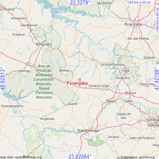
Porangaba GPS coordinates[2]
23° 10' 32.988" South, 48° 7' 30" West
| Map corner | latitude | longitude |
|---|---|---|
| Upper-left | -22.5279°, | -48.82813° |
| Center: | -23.17583°, | -48.125° |
| Lower-right: | -23.82064°, | -47.42188° |
| Map W x H: | 143.7×143.7 km | = 89.3×89.3mi |
| max Lat: | 2.81972° ⇑80.1% North |
| Porangaba: | -23.17583° |
| min Lat: | ⇓19.9% South -33.69111° |
| min Long | Porangaba | max Long |
| -72.89583° | -48.125° | -32.41083° |
| W 34.9%⇐ | ⇒65.1% E |
Elevation
Elevation of Porangaba is 544 m = 1785 ft, and this is 163.1 m = 535 ft above average elevation for this country.
| Max E: |
1603 m = 5259 ft | 33% |
| Porangaba | 544 m 1785 ft | |
| Avg. | 380.9 m = 1250 ft | |
Min E: |
0 m = 0 ft | 67% |
See also: Brazil elevation on elevation.city.
Geographical zone
Porangaba is located in South Torrid zone (between Equator and Tropic of Capricorn). Distance of this Southern Tropic circle is 29 km =18 mi to South.| Distance of | km | miles | from Porangaba |
|---|---|---|---|
| Equator | 2576.9 | 1601.2 | to North |
| Tropic Capricorn | 29 | 18 | to South |
| Antarctic Circle | 4824.3 | 2997.7 | to South |
| South Pole | 7430.2 | 4616.9 | to South |


Nearby cities:
15 places around Porangaba: (largest is in red/bold)
• Angatuba
45.6 km =28.3 mi,  220°
220°
• Araçoiaba da Serra
63.7 km =39.6 mi,  125°
125°
• Boituva
47.8 km =29.7 mi,  104°
104°
• Botucatu
46 km =28.6 mi,  314°
314°
• Capela do Alto
51.6 km =32.1 mi, 129°
• Cerquilho
39 km =24.2 mi,  88°
88°
• Conchas
21.3 km =13.2 mi,  33°
33°
• Iperó
48.6 km =30.2 mi,  113°
113°
• Itapetininga
46.8 km =29.1 mi,  170°
170°
• Itatinga
50.9 km =31.6 mi,  279°
279°
• Laranjal Paulista
32.7 km =20.3 mi,  64°
64°
• Porto Feliz
61.6 km =38.3 mi, 94°
• Rio das Pedras
64.7 km =40.2 mi, 55°
• Tatuí
33.9 km =21.1 mi, 126°
• Tietê
42.7 km =26.5 mi,  78°
78°
Sources, notices
• [Note1] Compared only with cities in Brazil existing in our database
• [Src1] Map data: © OpenStreetMap contributors (CC-BY-SA)
• [Src2] Other city data from geonames.org with taken over terms of usage.
• [Src3] Geographical zone / Annual Mean Temperature by Robert A. Rohde @ Wikipedia
