Governador Valadares geodata
Governador Valadares (Minas Gerais) is a populated place; located in Brazil in America/Sao_Paulo (GMT-3) time zone. With population of 250,878 people, there are 89 cities with bigger population in this country. Compared to other cities in Brazil, 52.9% of cities are located further ↑North; 66% of cities are located further ←West and 64.8% of cities have higher elevation than Governador Valadares. Note1


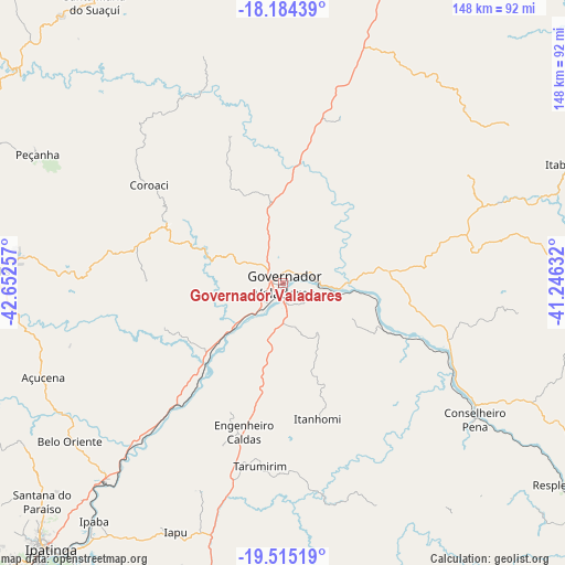
Governador Valadares GPS coordinates[2]
18° 51' 3.996" South, 41° 56' 57.984" West
| Map corner | latitude | longitude |
|---|---|---|
| Upper-left | -18.18439°, | -42.65257° |
| Center: | -18.85111°, | -41.94944° |
| Lower-right: | -19.51519°, | -41.24632° |
| Map W x H: | 148×148 km | = 92×92mi |
| max Lat: | 2.81972° ⇑52.9% North |
| Governador Valadares: | -18.85111° |
| min Lat: | ⇓47.1% South -33.69111° |
| min Long | Governador Vala | max Long |
| -72.89583° | -41.94944° | -32.41083° |
| W 66%⇐ | ⇒34% E |
Elevation
Elevation of Governador Valadares is 169 m = 554 ft, and this is 211.9 m = 695 ft below average elevation for this country.
| Max E: |
1603 m = 5259 ft | 64.8% |
| Avg. | 380.9 m = 1250 ft | |
| Governador Valadares | 169 m = 554 ft | |
Min E: |
0 m = 0 ft | 35.2% |
See also: Governador Valadares elevation on elevation.city.
Geographical zone
Governador Valadares is located in South Torrid zone (between Equator and Tropic of Capricorn). Distance of this Southern Tropic circle is 509.9 km =316.8 mi to South.| Distance of | km | miles | from Governador Valadares |
|---|---|---|---|
| Equator | 2096 | 1302.4 | to North |
| Tropic Capricorn | 509.9 | 316.8 | to South |
| Antarctic Circle | 5305.1 | 3296.4 | to South |
| South Pole | 7911 | 4915.7 | to South |


Nearby cities:
15 places around Governador Valadares: (largest is in red/bold)
• Açucena
67.4 km =41.9 mi,  248°
248°
• Belo Oriente
69.5 km =43.2 mi,  233°
233°
• Conselheiro Pena
61.6 km =38.3 mi,  125°
125°
• Coronel Fabriciano
103 km =64 mi,  223°
223°
• Divino das Laranjeiras
50.1 km =31.1 mi,  80°
80°
• Inhapim
79.7 km =49.5 mi,  192°
192°
• Ipaba
79.7 km =49.5 mi, 218°
• Ipatinga
92.3 km =57.4 mi, 221°
• Itambacuri
95.3 km =59.2 mi,  17°
17°
• Mantenópolis
87 km =54.1 mi,  90°
90°
• Peçanha
72.3 km =44.9 mi,  297°
297°
• Resplendor
90 km =55.9 mi, 125°
• Santa Maria do Suaçuí
88.3 km =54.9 mi,  326°
326°
• Santana do Paraíso
86.5 km =53.7 mi, 228°
• São João Evangelista
92.1 km =57.2 mi,  291°
291°
Sources, notices
• [Note1] Compared only with cities in Brazil existing in our database
• [Src1] Map data: © OpenStreetMap contributors (CC-BY-SA)
• [Src2] Other city data from geonames.org with taken over terms of usage.
• [Src3] Geographical zone / Annual Mean Temperature by Robert A. Rohde @ Wikipedia
