Uruguaiana geodata
Uruguaiana (Rio Grande do Sul) is a populated place; located in Brazil in America/Sao_Paulo (GMT-3) time zone. With population of 123,480 people, there are 181 cities with bigger population in this country. Compared to other cities in Brazil, 97.8% of cities are located further ↑North; 96.4% of cities are located further →East and 74.8% of cities have higher elevation than Uruguaiana. Note1


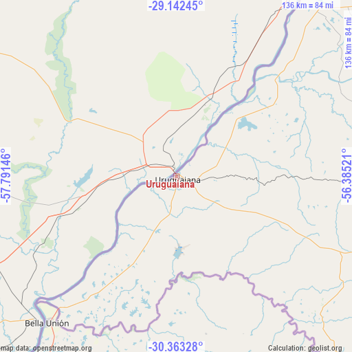
Uruguaiana GPS coordinates[2]
29° 45' 16.992" South, 57° 5' 17.988" West
| Map corner | latitude | longitude |
|---|---|---|
| Upper-left | -29.14245°, | -57.79146° |
| Center: | -29.75472°, | -57.08833° |
| Lower-right: | -30.36328°, | -56.38521° |
| Map W x H: | 135.7×135.7 km | = 84.3×84.3mi |
| max Lat: | 2.81972° ⇑97.8% North |
| Uruguaiana: | -29.75472° |
| min Lat: | ⇓2.2% South -33.69111° |
| min Long | Uruguaiana | max Long |
| -72.89583° | -57.08833° | -32.41083° |
| W 3.6%⇐ | ⇒96.4% E |
Elevation
Elevation of Uruguaiana is 79 m = 259 ft, and this is 301.9 m = 990 ft below average elevation for this country.
| Max E: |
1603 m = 5259 ft | 74.8% |
| Avg. | 380.9 m = 1250 ft | |
| Uruguaiana | 79 m = 259 ft | |
Min E: |
0 m = 0 ft | 25.2% |
See also: Uruguaiana elevation on elevation.city.
Geographical zone
Uruguaiana is located in South temperate zone (between Tropic of Capricorn and the Antarctic Circle). Distance of this Southern Tropic circle is 702.5 km =436.5 mi to North.| Distance of | km | miles | from Uruguaiana |
|---|---|---|---|
| Equator | 3308.4 | 2055.7 | to North |
| Tropic Capricorn | 702.5 | 436.5 | to North |
| Antarctic Circle | 4092.8 | 2543.1 | to South |
| South Pole | 6698.6 | 4162.3 | to South |


Nearby cities:
15 places around Uruguaiana: (largest is in red/bold)
• Alegrete
125.2 km =77.8 mi,  91°
91°
• Butia Inferior
284.6 km =176.8 mi,  48°
48°
• Cacequi
218.8 km =136 mi, 93°
• Cerro Largo
290.1 km =180.3 mi, 52°
• Dom Pedrito
268.9 km =167.1 mi,  120°
120°
• Itaqui
87.1 km =54.1 mi,  36°
36°
• Quaraí
93.3 km =58 mi,  138°
138°
• Rosário do Sul
216.7 km =134.7 mi,  104°
104°
• Santana do Livramento
195.6 km =121.5 mi,  130°
130°
• Santiago
223.9 km =139.1 mi,  73°
73°
• São Borja
160.8 km =99.9 mi, 40°
• São Francisco de Assis
190.5 km =118.4 mi,  83°
83°
• São Gabriel
274.2 km =170.4 mi, 103°
• São Luiz Gonzaga
255.2 km =158.6 mi, 54°
• São Pedro do Sul
281.4 km =174.9 mi, 86°
Sources, notices
• [Note1] Compared only with cities in Brazil existing in our database
• [Src1] Map data: © OpenStreetMap contributors (CC-BY-SA)
• [Src2] Other city data from geonames.org with taken over terms of usage.
• [Src3] Geographical zone / Annual Mean Temperature by Robert A. Rohde @ Wikipedia
