Bagé geodata
Bagé (Rio Grande do Sul) is a populated place; located in Brazil in America/Sao_Paulo (GMT-3) time zone. With population of 98,940 people, there are 235 cities with bigger population in this country. Compared to other cities in Brazil, 99.5% of cities are located further ↑North; 92.8% of cities are located further →East and 60.5% of cities have higher elevation than Bagé. Note1


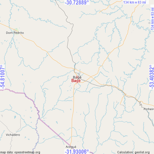
Bagé GPS coordinates[2]
31° 19' 53.004" South, 54° 6' 24.984" West
| Map corner | latitude | longitude |
|---|---|---|
| Upper-left | -30.72889°, | -54.81007° |
| Center: | -31.33139°, | -54.10694° |
| Lower-right: | -31.93006°, | -53.40382° |
| Map W x H: | 133.6×133.6 km | = 83×83mi |
| max Lat: | 2.81972° ⇑99.5% North |
| Bagé: | -31.33139° |
| min Lat: | ⇓0.5% South -33.69111° |
| min Long | Bagé | max Long |
| -72.89583° | -54.10694° | -32.41083° |
| W 7.2%⇐ | ⇒92.8% E |
Elevation
Elevation of Bagé is 206 m = 676 ft, and this is 174.9 m = 574 ft below average elevation for this country.
| Max E: |
1603 m = 5259 ft | 60.5% |
| Avg. | 380.9 m = 1250 ft | |
| Bagé | 206 m = 676 ft | |
Min E: |
0 m = 0 ft | 39.5% |
See also: Bagé elevation on elevation.city.
Geographical zone
Bagé is located in South temperate zone (between Tropic of Capricorn and the Antarctic Circle). Distance of this Southern Tropic circle is 877.8 km =545.4 mi to North.| Distance of | km | miles | from Bagé |
|---|---|---|---|
| Equator | 3483.7 | 2164.7 | to North |
| Tropic Capricorn | 877.8 | 545.4 | to North |
| Antarctic Circle | 3917.5 | 2434.2 | to South |
| South Pole | 6523.3 | 4053.4 | to South |


Nearby cities:
15 places around Bagé: (largest is in red/bold)
• Arroio Grande
139.4 km =86.6 mi,  136°
136°
• Cacequi
175 km =108.7 mi,  336°
336°
• Cachoeira do Sul
184.7 km =114.8 mi,  38°
38°
• Canguçu
136.1 km =84.6 mi,  92°
92°
• Caçapava do Sul
108.5 km =67.4 mi,  33°
33°
• Dom Pedrito
66.4 km =41.3 mi,  305°
305°
• Encruzilhada do Sul
174.7 km =108.6 mi,  59°
59°
• Herval
102.2 km =63.5 mi, 138°
• Jaguarão
153.6 km =95.4 mi,  153°
153°
• Pelotas
174.3 km =108.3 mi,  106°
106°
• Pinheiro Machado
74.1 km =46 mi, 111°
• Rosário do Sul
142.1 km =88.3 mi,  327°
327°
• Santana do Livramento
144.3 km =89.7 mi,  289°
289°
• São Gabriel
112.5 km =69.9 mi,  349°
349°
• São Sepé
140.1 km =87.1 mi,  21°
21°
Sources, notices
• [Note1] Compared only with cities in Brazil existing in our database
• [Src1] Map data: © OpenStreetMap contributors (CC-BY-SA)
• [Src2] Other city data from geonames.org with taken over terms of usage.
• [Src3] Geographical zone / Annual Mean Temperature by Robert A. Rohde @ Wikipedia
